You are here: Home > Network List > IU - Global Seismograph Network (GSN - IRIS/USGS) Stations List
> Station GUMO Guam, Mariana Islands > Earthquake Result Viewer
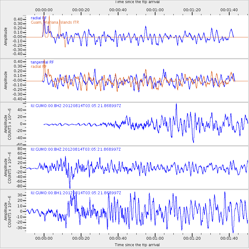
GUMO Guam, Mariana Islands - Earthquake Result Viewer
*The percent match for this event was below the threshold and hence no stack was calculated.
| Earthquake location: |
Sea Of Okhotsk |
| Earthquake latitude/longitude: |
49.8/145.1 |
| Earthquake time(UTC): |
2012/08/14 (227) 02:59:38 GMT |
| Earthquake Depth: |
583 km |
| Earthquake Magnitude: |
6.9 MB, 7.7 MW, 7.7 MW |
| Earthquake Catalog/Contributor: |
WHDF/NEIC |
|
| Network: |
IU Global Seismograph Network (GSN - IRIS/USGS) |
| Station: |
GUMO Guam, Mariana Islands |
| Lat/Lon: |
13.59 N/144.87 E |
| Elevation: |
170 m |
|
| Distance: |
36.1 deg |
| Az: |
180.323 deg |
| Baz: |
0.215 deg |
| Ray Param: |
$rayparam |
*The percent match for this event was below the threshold and hence was not used in the summary stack. |
|
| Radial Match: |
67.33631 % |
| Radial Bump: |
400 |
| Transverse Match: |
57.003857 % |
| Transverse Bump: |
400 |
| SOD ConfigId: |
558545 |
| Insert Time: |
2013-09-17 17:03:42.368 +0000 |
| GWidth: |
2.5 |
| Max Bumps: |
400 |
| Tol: |
0.001 |
|
Signal To Noise
| Channel | StoN | STA | LTA |
| IU:GUMO:00:BHZ:20120814T03:05:21.868997Z | 5.8992357 | 1.081097E-5 | 1.8326052E-6 |
| IU:GUMO:00:BH1:20120814T03:05:21.868997Z | 2.4461777 | 5.314912E-6 | 2.1727415E-6 |
| IU:GUMO:00:BH2:20120814T03:05:21.868997Z | 1.587228 | 2.5969043E-6 | 1.6361256E-6 |
| Arrivals |
| Ps | |
| PpPs | |
| PsPs/PpSs | |


