You are here: Home > Network List > IU - Global Seismograph Network (GSN - IRIS/USGS) Stations List
> Station HNR Honiara, Solomon Islands > Earthquake Result Viewer
HNR Honiara, Solomon Islands - Earthquake Result Viewer
| Earthquake location: |
Sea Of Okhotsk |
| Earthquake latitude/longitude: |
49.8/145.1 |
| Earthquake time(UTC): |
2012/08/14 (227) 02:59:38 GMT |
| Earthquake Depth: |
583 km |
| Earthquake Magnitude: |
6.9 MB, 7.7 MW, 7.7 MW |
| Earthquake Catalog/Contributor: |
WHDF/NEIC |
|
| Network: |
IU Global Seismograph Network (GSN - IRIS/USGS) |
| Station: |
HNR Honiara, Solomon Islands |
| Lat/Lon: |
9.44 S/159.95 E |
| Elevation: |
100 m |
|
| Distance: |
60.4 deg |
| Az: |
163.056 deg |
| Baz: |
348.966 deg |
| Ray Param: |
0.05923874 |
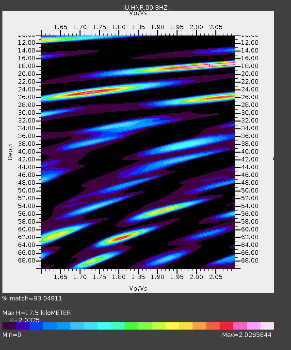
| Estimated Moho Depth: |
17.5 km |
| Estimated Crust Vp/Vs: |
2.03 |
| Assumed Crust Vp: |
6.183 km/s |
| Estimated Crust Vs: |
3.042 km/s |
| Estimated Crust Poisson's Ratio: |
0.34 |
|
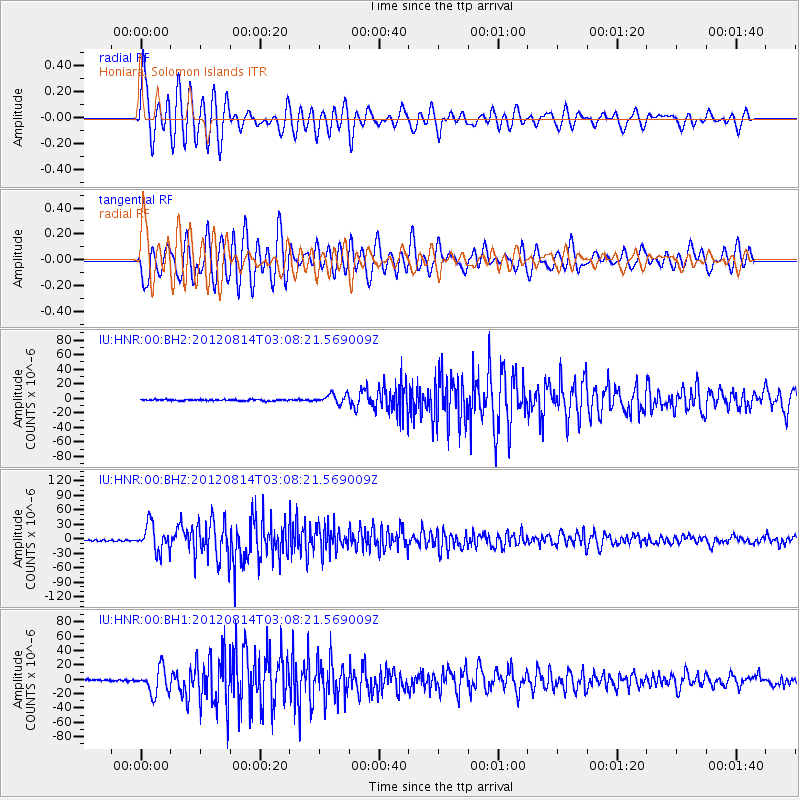
| Radial Match: |
83.04911 % |
| Radial Bump: |
400 |
| Transverse Match: |
81.90817 % |
| Transverse Bump: |
400 |
| SOD ConfigId: |
558545 |
| Insert Time: |
2013-09-17 17:03:47.003 +0000 |
| GWidth: |
2.5 |
| Max Bumps: |
400 |
| Tol: |
0.001 |
|
Signal To Noise
| Channel | StoN | STA | LTA |
| IU:HNR:00:BHZ:20120814T03:08:21.569009Z | 23.155546 | 2.781589E-5 | 1.2012625E-6 |
| IU:HNR:00:BH1:20120814T03:08:21.569009Z | 20.71281 | 1.7721995E-5 | 8.5560555E-7 |
| IU:HNR:00:BH2:20120814T03:08:21.569009Z | 7.5190077 | 6.5210456E-6 | 8.6727476E-7 |
| Arrivals |
| Ps | 3.0 SECOND |
| PpPs | 8.3 SECOND |
| PsPs/PpSs | 11 SECOND |


