You are here: Home > Network List > IU - Global Seismograph Network (GSN - IRIS/USGS) Stations List
> Station WAKE Wake Island > Earthquake Result Viewer
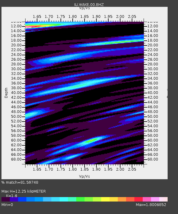
WAKE Wake Island - Earthquake Result Viewer
| Earthquake location: |
Sea Of Okhotsk |
| Earthquake latitude/longitude: |
49.8/145.1 |
| Earthquake time(UTC): |
2012/08/14 (227) 02:59:38 GMT |
| Earthquake Depth: |
583 km |
| Earthquake Magnitude: |
6.9 MB, 7.7 MW, 7.7 MW |
| Earthquake Catalog/Contributor: |
WHDF/NEIC |
|
| Network: |
IU Global Seismograph Network (GSN - IRIS/USGS) |
| Station: |
WAKE Wake Island |
| Lat/Lon: |
19.28 N/166.65 E |
| Elevation: |
20 m |
|
| Distance: |
35.0 deg |
| Az: |
142.703 deg |
| Baz: |
335.438 deg |
| Ray Param: |
0.07450687 |
| Estimated Moho Depth: |
12.25 km |
| Estimated Crust Vp/Vs: |
1.60 |
| Assumed Crust Vp: |
4.24 km/s |
| Estimated Crust Vs: |
2.65 km/s |
| Estimated Crust Poisson's Ratio: |
0.18 |
|
| Radial Match: |
81.59748 % |
| Radial Bump: |
397 |
| Transverse Match: |
55.11201 % |
| Transverse Bump: |
400 |
| SOD ConfigId: |
558545 |
| Insert Time: |
2013-09-17 17:05:12.559 +0000 |
| GWidth: |
2.5 |
| Max Bumps: |
400 |
| Tol: |
0.001 |
|

Signal To Noise
| Channel | StoN | STA | LTA |
| IU:WAKE:00:BHZ:20120814T03:05:12.719003Z | 23.079473 | 1.4308777E-5 | 6.199785E-7 |
| IU:WAKE:00:BH1:20120814T03:05:12.719003Z | 3.6118522 | 7.088333E-6 | 1.9625202E-6 |
| IU:WAKE:00:BH2:20120814T03:05:12.719003Z | 2.4705055 | 4.270212E-6 | 1.7284768E-6 |
| Arrivals |
| Ps | 1.8 SECOND |
| PpPs | 7.3 SECOND |
| PsPs/PpSs | 9.1 SECOND |


