You are here: Home > Network List > KN - Kyrgyz Seismic Telemetry Network Stations List
> Station TKM2 - > Earthquake Result Viewer
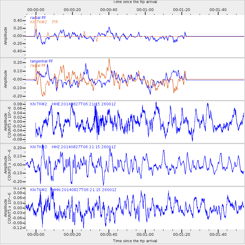
TKM2 - - Earthquake Result Viewer
*The percent match for this event was below the threshold and hence no stack was calculated.
| Earthquake location: |
Gulf Of Alaska |
| Earthquake latitude/longitude: |
59.2/-145.6 |
| Earthquake time(UTC): |
2014/08/27 (239) 06:10:19 GMT |
| Earthquake Depth: |
12 km |
| Earthquake Magnitude: |
5.1 Mww, 4.8 ML, 5.0 mb, 4.7 Ms_20 |
| Earthquake Catalog/Contributor: |
ISC/ISC |
|
| Network: |
KN Kyrgyz Seismic Telemetry Network |
| Station: |
TKM2 - |
| Lat/Lon: |
42.92 N/75.60 E |
| Elevation: |
2020 m |
|
| Distance: |
72.7 deg |
| Az: |
329.568 deg |
| Baz: |
20.768 deg |
| Ray Param: |
$rayparam |
*The percent match for this event was below the threshold and hence was not used in the summary stack. |
|
| Radial Match: |
63.44622 % |
| Radial Bump: |
400 |
| Transverse Match: |
54.307396 % |
| Transverse Bump: |
400 |
| SOD ConfigId: |
3390531 |
| Insert Time: |
2019-04-13 15:55:21.174 +0000 |
| GWidth: |
2.5 |
| Max Bumps: |
400 |
| Tol: |
0.001 |
|
Signal To Noise
| Channel | StoN | STA | LTA |
| KN:TKM2: :HHZ:20140827T06:21:15.26001Z | 2.9993184 | 1.0716687E-7 | 3.573041E-8 |
| KN:TKM2: :HHN:20140827T06:21:15.26001Z | 1.3779637 | 5.08058E-8 | 3.68702E-8 |
| KN:TKM2: :HHE:20140827T06:21:15.26001Z | 0.92763555 | 3.3834986E-8 | 3.647444E-8 |
| Arrivals |
| Ps | |
| PpPs | |
| PsPs/PpSs | |


