You are here: Home > Network List > US - United States National Seismic Network Stations List
> Station TPNV Topopah Spring, Nevada, USA > Earthquake Result Viewer
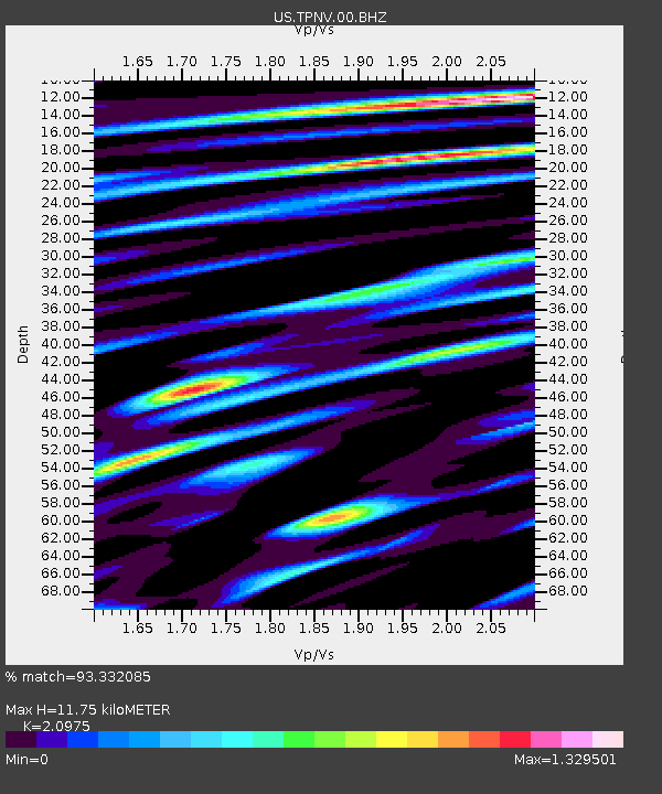
TPNV Topopah Spring, Nevada, USA - Earthquake Result Viewer
| Earthquake location: |
Sea Of Okhotsk |
| Earthquake latitude/longitude: |
49.8/145.1 |
| Earthquake time(UTC): |
2012/08/14 (227) 02:59:38 GMT |
| Earthquake Depth: |
583 km |
| Earthquake Magnitude: |
6.9 MB, 7.7 MW, 7.7 MW |
| Earthquake Catalog/Contributor: |
WHDF/NEIC |
|
| Network: |
US United States National Seismic Network |
| Station: |
TPNV Topopah Spring, Nevada, USA |
| Lat/Lon: |
36.95 N/116.25 W |
| Elevation: |
1600 m |
|
| Distance: |
67.8 deg |
| Az: |
58.78 deg |
| Baz: |
316.233 deg |
| Ray Param: |
0.054621506 |
| Estimated Moho Depth: |
11.75 km |
| Estimated Crust Vp/Vs: |
2.10 |
| Assumed Crust Vp: |
6.279 km/s |
| Estimated Crust Vs: |
2.993 km/s |
| Estimated Crust Poisson's Ratio: |
0.35 |
|
| Radial Match: |
93.332085 % |
| Radial Bump: |
400 |
| Transverse Match: |
90.40992 % |
| Transverse Bump: |
400 |
| SOD ConfigId: |
558545 |
| Insert Time: |
2013-09-17 17:08:33.289 +0000 |
| GWidth: |
2.5 |
| Max Bumps: |
400 |
| Tol: |
0.001 |
|

Signal To Noise
| Channel | StoN | STA | LTA |
| US:TPNV:00:BHZ:20120814T03:09:08.324014Z | 87.90453 | 1.4896061E-5 | 1.6945725E-7 |
| US:TPNV:00:BH1:20120814T03:09:08.324014Z | 35.029095 | 4.180376E-6 | 1.193401E-7 |
| US:TPNV:00:BH2:20120814T03:09:08.324014Z | 41.22087 | 3.964015E-6 | 9.616524E-8 |
| Arrivals |
| Ps | 2.1 SECOND |
| PpPs | 5.6 SECOND |
| PsPs/PpSs | 7.7 SECOND |


