You are here: Home > Network List > US - United States National Seismic Network Stations List
> Station WRAK Wrangell Island, Southeastern Alaska, Alaska, USA > Earthquake Result Viewer
WRAK Wrangell Island, Southeastern Alaska, Alaska, USA - Earthquake Result Viewer
| Earthquake location: |
Sea Of Okhotsk |
| Earthquake latitude/longitude: |
49.8/145.1 |
| Earthquake time(UTC): |
2012/08/14 (227) 02:59:38 GMT |
| Earthquake Depth: |
583 km |
| Earthquake Magnitude: |
6.9 MB, 7.7 MW, 7.7 MW |
| Earthquake Catalog/Contributor: |
WHDF/NEIC |
|
| Network: |
US United States National Seismic Network |
| Station: |
WRAK Wrangell Island, Southeastern Alaska, Alaska, USA |
| Lat/Lon: |
56.42 N/132.35 W |
| Elevation: |
81 m |
|
| Distance: |
47.2 deg |
| Az: |
48.698 deg |
| Baz: |
298.834 deg |
| Ray Param: |
0.06736096 |
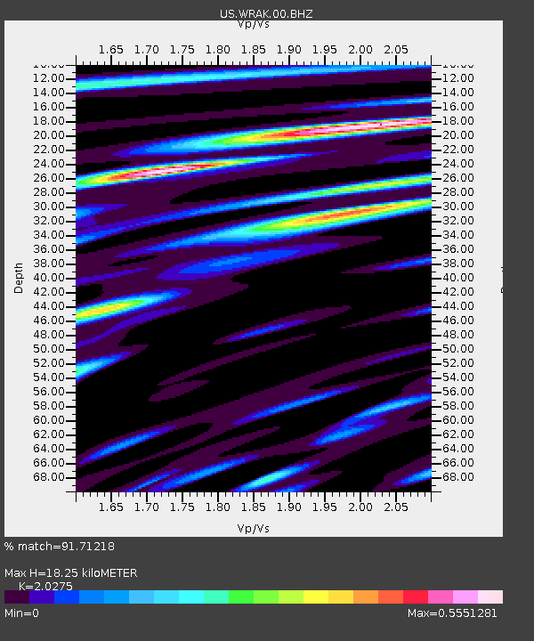
| Estimated Moho Depth: |
18.25 km |
| Estimated Crust Vp/Vs: |
2.03 |
| Assumed Crust Vp: |
6.597 km/s |
| Estimated Crust Vs: |
3.254 km/s |
| Estimated Crust Poisson's Ratio: |
0.34 |
|
| Radial Match: |
91.71218 % |
| Radial Bump: |
376 |
| Transverse Match: |
74.960144 % |
| Transverse Bump: |
400 |
| SOD ConfigId: |
558545 |
| Insert Time: |
2013-09-17 17:08:51.255 +0000 |
| GWidth: |
2.5 |
| Max Bumps: |
400 |
| Tol: |
0.001 |
|
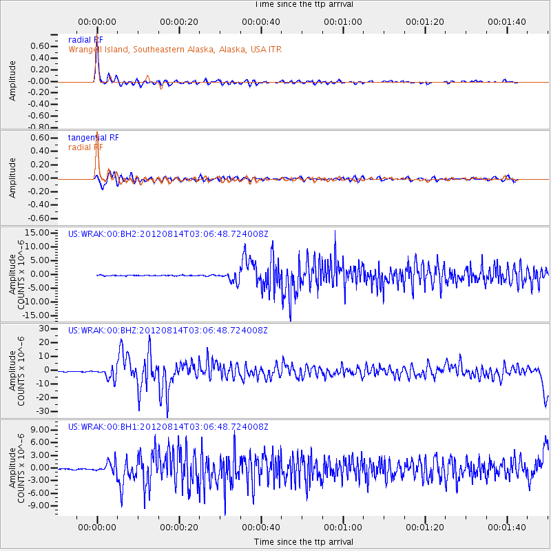
Signal To Noise
| Channel | StoN | STA | LTA |
| US:WRAK:00:BHZ:20120814T03:06:48.724008Z | 33.083992 | 3.9892643E-6 | 1.205799E-7 |
| US:WRAK:00:BH1:20120814T03:06:48.724008Z | 12.544626 | 1.3326957E-6 | 1.0623638E-7 |
| US:WRAK:00:BH2:20120814T03:06:48.724008Z | 14.049785 | 1.7701518E-6 | 1.2599139E-7 |
| Arrivals |
| Ps | 3.0 SECOND |
| PpPs | 8.0 SECOND |
| PsPs/PpSs | 11 SECOND |


