You are here: Home > Network List > TA - USArray Transportable Network (new EarthScope stations) Stations List
> Station BGNE Belgrade, NE, USA > Earthquake Result Viewer
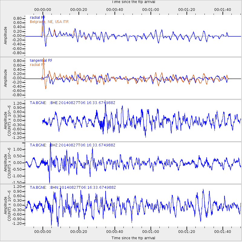
BGNE Belgrade, NE, USA - Earthquake Result Viewer
*The percent match for this event was below the threshold and hence no stack was calculated.
| Earthquake location: |
Gulf Of Alaska |
| Earthquake latitude/longitude: |
59.2/-145.6 |
| Earthquake time(UTC): |
2014/08/27 (239) 06:10:19 GMT |
| Earthquake Depth: |
12 km |
| Earthquake Magnitude: |
5.1 Mww, 4.8 ML, 5.0 mb, 4.7 Ms_20 |
| Earthquake Catalog/Contributor: |
ISC/ISC |
|
| Network: |
TA USArray Transportable Network (new EarthScope stations) |
| Station: |
BGNE Belgrade, NE, USA |
| Lat/Lon: |
41.41 N/98.15 W |
| Elevation: |
573 m |
|
| Distance: |
34.2 deg |
| Az: |
99.997 deg |
| Baz: |
317.681 deg |
| Ray Param: |
$rayparam |
*The percent match for this event was below the threshold and hence was not used in the summary stack. |
|
| Radial Match: |
64.153244 % |
| Radial Bump: |
400 |
| Transverse Match: |
49.430145 % |
| Transverse Bump: |
400 |
| SOD ConfigId: |
3390531 |
| Insert Time: |
2019-04-13 15:57:25.590 +0000 |
| GWidth: |
2.5 |
| Max Bumps: |
400 |
| Tol: |
0.001 |
|
Signal To Noise
| Channel | StoN | STA | LTA |
| TA:BGNE: :BHZ:20140827T06:16:33.674988Z | 2.7279074 | 5.2741785E-7 | 1.9334155E-7 |
| TA:BGNE: :BHN:20140827T06:16:33.674988Z | 1.3537687 | 3.5061822E-7 | 2.589942E-7 |
| TA:BGNE: :BHE:20140827T06:16:33.674988Z | 1.6971457 | 4.2638578E-7 | 2.51237E-7 |
| Arrivals |
| Ps | |
| PpPs | |
| PsPs/PpSs | |


