You are here: Home > Network List > US - United States National Seismic Network Stations List
> Station SCIA State Center, Iowa, USA > Earthquake Result Viewer
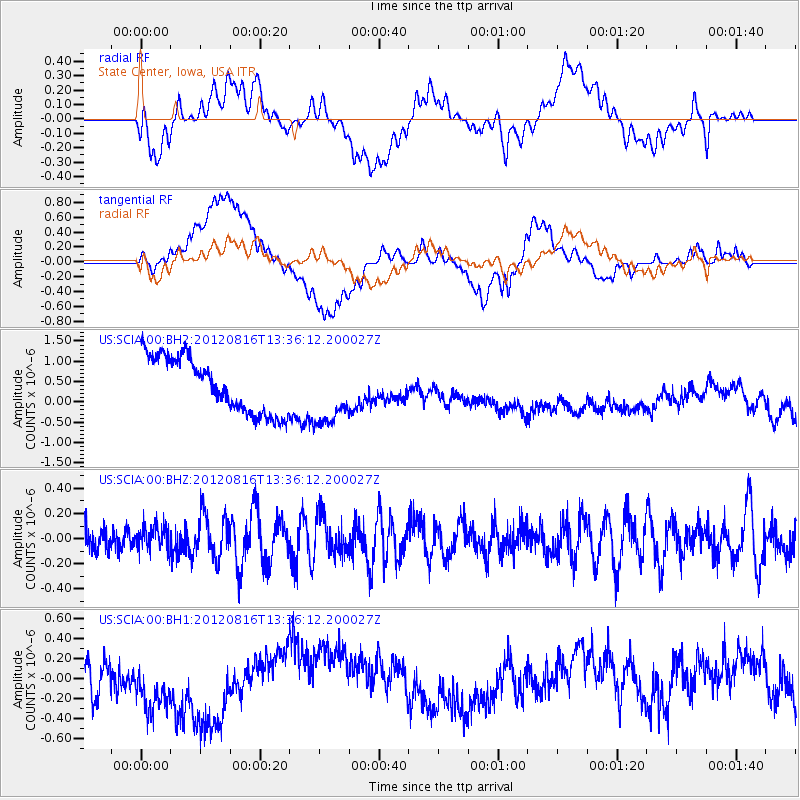
SCIA State Center, Iowa, USA - Earthquake Result Viewer
*The percent match for this event was below the threshold and hence no stack was calculated.
| Earthquake location: |
Southeast Of Easter Island |
| Earthquake latitude/longitude: |
-36.4/-98.9 |
| Earthquake time(UTC): |
2012/08/16 (229) 13:24:44 GMT |
| Earthquake Depth: |
10 km |
| Earthquake Magnitude: |
5.8 MW, 5.7 MW |
| Earthquake Catalog/Contributor: |
NEIC PDE/NEIC PDE-W |
|
| Network: |
US United States National Seismic Network |
| Station: |
SCIA State Center, Iowa, USA |
| Lat/Lon: |
41.91 N/93.22 W |
| Elevation: |
312 m |
|
| Distance: |
78.1 deg |
| Az: |
4.337 deg |
| Baz: |
184.686 deg |
| Ray Param: |
$rayparam |
*The percent match for this event was below the threshold and hence was not used in the summary stack. |
|
| Radial Match: |
18.417383 % |
| Radial Bump: |
400 |
| Transverse Match: |
15.81464 % |
| Transverse Bump: |
400 |
| SOD ConfigId: |
558545 |
| Insert Time: |
2013-09-17 17:20:37.208 +0000 |
| GWidth: |
2.5 |
| Max Bumps: |
400 |
| Tol: |
0.001 |
|
Signal To Noise
| Channel | StoN | STA | LTA |
| US:SCIA:00:BHZ:20120816T13:36:12.200027Z | 0.90038985 | 9.732901E-8 | 1.08096515E-7 |
| US:SCIA:00:BH1:20120816T13:36:12.200027Z | 1.9302517 | 3.791199E-7 | 1.9640957E-7 |
| US:SCIA:00:BH2:20120816T13:36:12.200027Z | 1.1798877 | 7.98566E-7 | 6.7681526E-7 |
| Arrivals |
| Ps | |
| PpPs | |
| PsPs/PpSs | |


