You are here: Home > Network List > US - United States National Seismic Network Stations List
> Station WVOR Wild Horse Valley, Oregon, USA > Earthquake Result Viewer
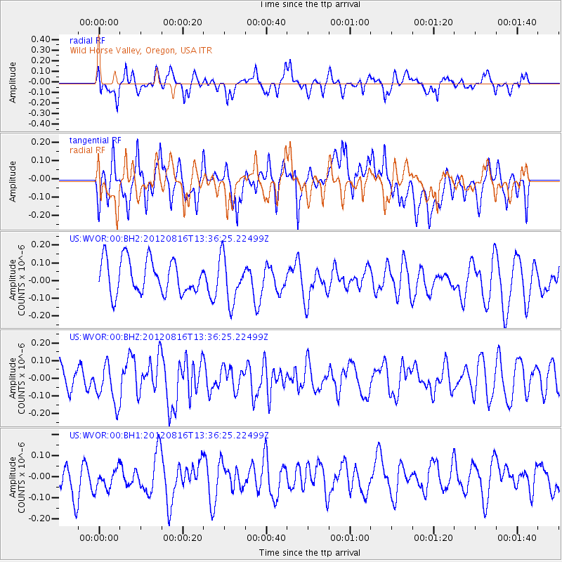
WVOR Wild Horse Valley, Oregon, USA - Earthquake Result Viewer
*The percent match for this event was below the threshold and hence no stack was calculated.
| Earthquake location: |
Southeast Of Easter Island |
| Earthquake latitude/longitude: |
-36.4/-98.9 |
| Earthquake time(UTC): |
2012/08/16 (229) 13:24:44 GMT |
| Earthquake Depth: |
10 km |
| Earthquake Magnitude: |
5.8 MW, 5.7 MW |
| Earthquake Catalog/Contributor: |
NEIC PDE/NEIC PDE-W |
|
| Network: |
US United States National Seismic Network |
| Station: |
WVOR Wild Horse Valley, Oregon, USA |
| Lat/Lon: |
42.43 N/118.64 W |
| Elevation: |
1344 m |
|
| Distance: |
80.5 deg |
| Az: |
345.322 deg |
| Baz: |
163.976 deg |
| Ray Param: |
$rayparam |
*The percent match for this event was below the threshold and hence was not used in the summary stack. |
|
| Radial Match: |
49.230232 % |
| Radial Bump: |
400 |
| Transverse Match: |
38.24472 % |
| Transverse Bump: |
400 |
| SOD ConfigId: |
558545 |
| Insert Time: |
2013-09-17 17:20:53.965 +0000 |
| GWidth: |
2.5 |
| Max Bumps: |
400 |
| Tol: |
0.001 |
|
Signal To Noise
| Channel | StoN | STA | LTA |
| US:WVOR:00:BHZ:20120816T13:36:25.22499Z | 1.6829813 | 1.1587549E-7 | 6.885132E-8 |
| US:WVOR:00:BH1:20120816T13:36:25.22499Z | 0.7607241 | 5.032442E-8 | 6.615331E-8 |
| US:WVOR:00:BH2:20120816T13:36:25.22499Z | 1.3591794 | 1.3069953E-7 | 9.6160626E-8 |
| Arrivals |
| Ps | |
| PpPs | |
| PsPs/PpSs | |


