You are here: Home > Network List > US - United States National Seismic Network Stations List
> Station DUG Dugway, Tooele County, Utah, USA > Earthquake Result Viewer
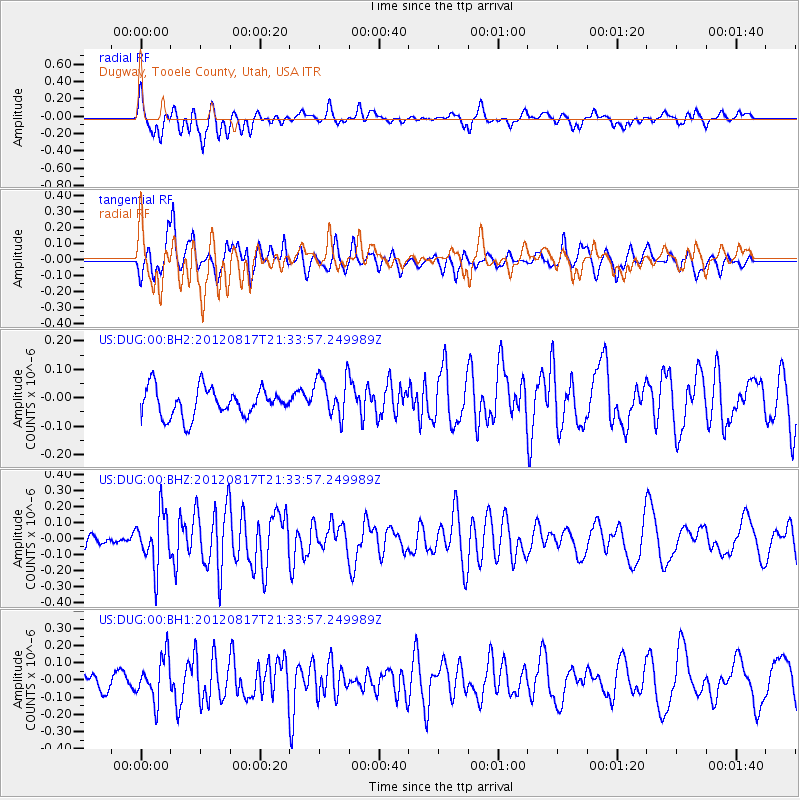
DUG Dugway, Tooele County, Utah, USA - Earthquake Result Viewer
*The percent match for this event was below the threshold and hence no stack was calculated.
| Earthquake location: |
Northern East Pacific Rise |
| Earthquake latitude/longitude: |
8.3/-103.0 |
| Earthquake time(UTC): |
2012/08/17 (230) 21:27:53 GMT |
| Earthquake Depth: |
10 km |
| Earthquake Magnitude: |
5.5 MW |
| Earthquake Catalog/Contributor: |
NEIC PDE/NEIC PDE-W |
|
| Network: |
US United States National Seismic Network |
| Station: |
DUG Dugway, Tooele County, Utah, USA |
| Lat/Lon: |
40.19 N/112.81 W |
| Elevation: |
1477 m |
|
| Distance: |
32.9 deg |
| Az: |
346.097 deg |
| Baz: |
161.917 deg |
| Ray Param: |
$rayparam |
*The percent match for this event was below the threshold and hence was not used in the summary stack. |
|
| Radial Match: |
66.64761 % |
| Radial Bump: |
400 |
| Transverse Match: |
59.105618 % |
| Transverse Bump: |
400 |
| SOD ConfigId: |
558545 |
| Insert Time: |
2013-09-17 17:23:34.336 +0000 |
| GWidth: |
2.5 |
| Max Bumps: |
400 |
| Tol: |
0.001 |
|
Signal To Noise
| Channel | StoN | STA | LTA |
| US:DUG:00:BHZ:20120817T21:33:57.249989Z | 3.0539849 | 1.6472991E-7 | 5.3939335E-8 |
| US:DUG:00:BH1:20120817T21:33:57.249989Z | 2.194674 | 1.2573771E-7 | 5.7292205E-8 |
| US:DUG:00:BH2:20120817T21:33:57.249989Z | 1.4823582 | 7.469019E-8 | 5.0386063E-8 |
| Arrivals |
| Ps | |
| PpPs | |
| PsPs/PpSs | |


