You are here: Home > Network List > II - Global Seismograph Network (GSN - IRIS/IDA) Stations List
> Station NIL Nilore, Pakistan > Earthquake Result Viewer
NIL Nilore, Pakistan - Earthquake Result Viewer
| Earthquake location: |
Sulawesi, Indonesia |
| Earthquake latitude/longitude: |
-1.3/120.1 |
| Earthquake time(UTC): |
2012/08/18 (231) 09:41:52 GMT |
| Earthquake Depth: |
10 km |
| Earthquake Magnitude: |
6.3 MW, 5.8 MB, 6.1 MS, 6.3 MW |
| Earthquake Catalog/Contributor: |
NEIC PDE/NEIC PDE-W |
|
| Network: |
II Global Seismograph Network (GSN - IRIS/IDA) |
| Station: |
NIL Nilore, Pakistan |
| Lat/Lon: |
33.65 N/73.27 E |
| Elevation: |
629 m |
|
| Distance: |
56.1 deg |
| Az: |
312.855 deg |
| Baz: |
118.525 deg |
| Ray Param: |
0.06437347 |
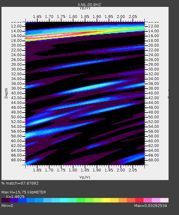
| Estimated Moho Depth: |
15.75 km |
| Estimated Crust Vp/Vs: |
1.69 |
| Assumed Crust Vp: |
6.242 km/s |
| Estimated Crust Vs: |
3.688 km/s |
| Estimated Crust Poisson's Ratio: |
0.23 |
|
| Radial Match: |
87.67892 % |
| Radial Bump: |
400 |
| Transverse Match: |
84.13098 % |
| Transverse Bump: |
400 |
| SOD ConfigId: |
558545 |
| Insert Time: |
2013-09-17 17:25:19.737 +0000 |
| GWidth: |
2.5 |
| Max Bumps: |
400 |
| Tol: |
0.001 |
|

Signal To Noise
| Channel | StoN | STA | LTA |
| II:NIL:00:BHZ:20120818T09:51:00.619006Z | 16.25916 | 2.031562E-6 | 1.2494877E-7 |
| II:NIL:00:BH1:20120818T09:51:00.619006Z | 2.863201 | 2.1981052E-7 | 7.67709E-8 |
| II:NIL:00:BH2:20120818T09:51:00.619006Z | 8.065779 | 3.434912E-7 | 4.2586237E-8 |
| Arrivals |
| Ps | 1.8 SECOND |
| PpPs | 6.5 SECOND |
| PsPs/PpSs | 8.3 SECOND |


