You are here: Home > Network List > IU - Global Seismograph Network (GSN - IRIS/USGS) Stations List
> Station MAKZ Makanchi, Kazakhstan > Earthquake Result Viewer
MAKZ Makanchi, Kazakhstan - Earthquake Result Viewer
| Earthquake location: |
Sulawesi, Indonesia |
| Earthquake latitude/longitude: |
-1.3/120.1 |
| Earthquake time(UTC): |
2012/08/18 (231) 09:41:52 GMT |
| Earthquake Depth: |
10 km |
| Earthquake Magnitude: |
6.3 MW, 5.8 MB, 6.1 MS, 6.3 MW |
| Earthquake Catalog/Contributor: |
NEIC PDE/NEIC PDE-W |
|
| Network: |
IU Global Seismograph Network (GSN - IRIS/USGS) |
| Station: |
MAKZ Makanchi, Kazakhstan |
| Lat/Lon: |
46.81 N/81.98 E |
| Elevation: |
600 m |
|
| Distance: |
58.4 deg |
| Az: |
330.151 deg |
| Baz: |
133.58 deg |
| Ray Param: |
0.062856086 |
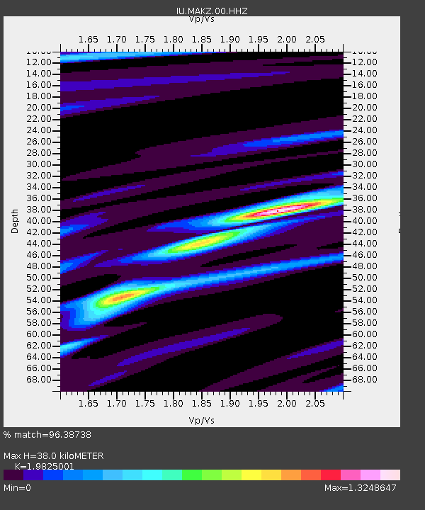
| Estimated Moho Depth: |
38.0 km |
| Estimated Crust Vp/Vs: |
1.98 |
| Assumed Crust Vp: |
6.571 km/s |
| Estimated Crust Vs: |
3.314 km/s |
| Estimated Crust Poisson's Ratio: |
0.33 |
|
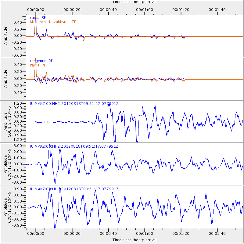
| Radial Match: |
96.38738 % |
| Radial Bump: |
258 |
| Transverse Match: |
75.40755 % |
| Transverse Bump: |
400 |
| SOD ConfigId: |
558545 |
| Insert Time: |
2013-09-17 17:26:19.131 +0000 |
| GWidth: |
2.5 |
| Max Bumps: |
400 |
| Tol: |
0.001 |
|
Signal To Noise
| Channel | StoN | STA | LTA |
| IU:MAKZ:00:HHZ:20120818T09:51:17.077991Z | 16.202974 | 6.654434E-7 | 4.1069214E-8 |
| IU:MAKZ:00:HH1:20120818T09:51:17.077991Z | 6.409072 | 1.6057935E-7 | 2.5055007E-8 |
| IU:MAKZ:00:HH2:20120818T09:51:17.077991Z | 10.752653 | 2.2053264E-7 | 2.0509603E-8 |
| Arrivals |
| Ps | 5.9 SECOND |
| PpPs | 16 SECOND |
| PsPs/PpSs | 22 SECOND |


