You are here: Home > Network List > US - United States National Seismic Network Stations List
> Station NLWA Neilton Lookout, Washington, USA > Earthquake Result Viewer
NLWA Neilton Lookout, Washington, USA - Earthquake Result Viewer
| Earthquake location: |
Vanuatu Islands Region |
| Earthquake latitude/longitude: |
-13.5/172.4 |
| Earthquake time(UTC): |
2012/08/18 (231) 10:23:32 GMT |
| Earthquake Depth: |
31 km |
| Earthquake Magnitude: |
5.7 MW, 5.7 MS |
| Earthquake Catalog/Contributor: |
NEIC PDE/NEIC PDE-W |
|
| Network: |
US United States National Seismic Network |
| Station: |
NLWA Neilton Lookout, Washington, USA |
| Lat/Lon: |
47.39 N/123.87 W |
| Elevation: |
640 m |
|
| Distance: |
83.0 deg |
| Az: |
37.877 deg |
| Baz: |
241.519 deg |
| Ray Param: |
0.046463195 |
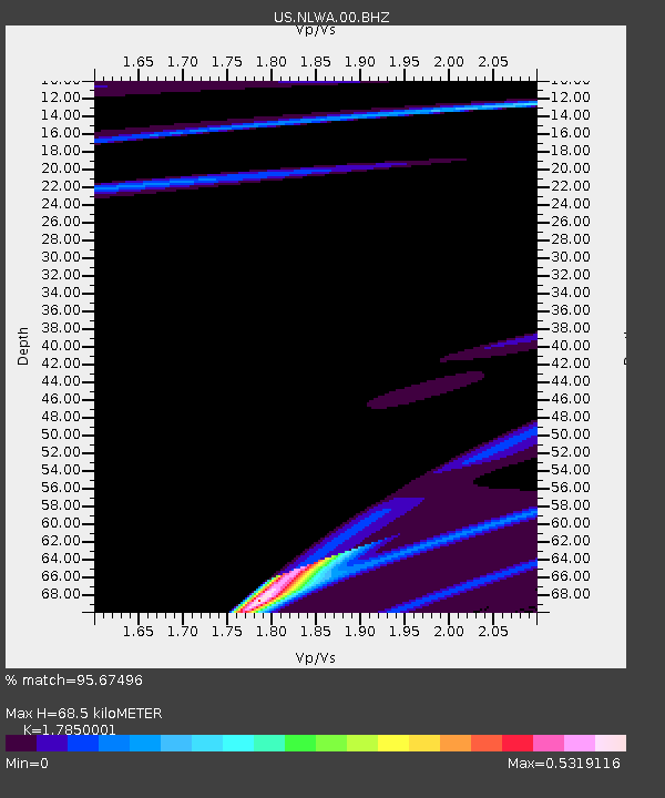
| Estimated Moho Depth: |
68.5 km |
| Estimated Crust Vp/Vs: |
1.79 |
| Assumed Crust Vp: |
6.566 km/s |
| Estimated Crust Vs: |
3.679 km/s |
| Estimated Crust Poisson's Ratio: |
0.27 |
|
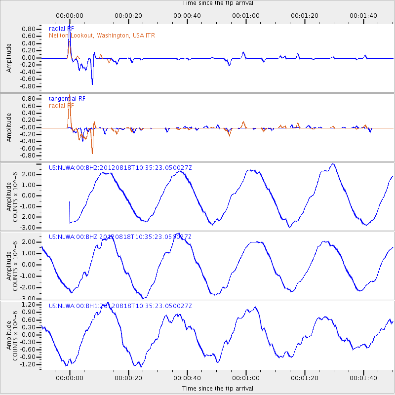
| Radial Match: |
95.67496 % |
| Radial Bump: |
327 |
| Transverse Match: |
90.99576 % |
| Transverse Bump: |
400 |
| SOD ConfigId: |
558545 |
| Insert Time: |
2013-09-17 17:29:06.896 +0000 |
| GWidth: |
2.5 |
| Max Bumps: |
400 |
| Tol: |
0.001 |
|
Signal To Noise
| Channel | StoN | STA | LTA |
| US:NLWA:00:BHZ:20120818T10:35:23.050027Z | 1.7311872 | 2.043242E-6 | 1.1802547E-6 |
| US:NLWA:00:BH1:20120818T10:35:23.050027Z | 2.297717 | 9.4768416E-7 | 4.1244596E-7 |
| US:NLWA:00:BH2:20120818T10:35:23.050027Z | 0.6303761 | 1.0313803E-6 | 1.6361349E-6 |
| Arrivals |
| Ps | 8.4 SECOND |
| PpPs | 28 SECOND |
| PsPs/PpSs | 37 SECOND |


