You are here: Home > Network List > IU - Global Seismograph Network (GSN - IRIS/USGS) Stations List
> Station HNR Honiara, Solomon Islands > Earthquake Result Viewer
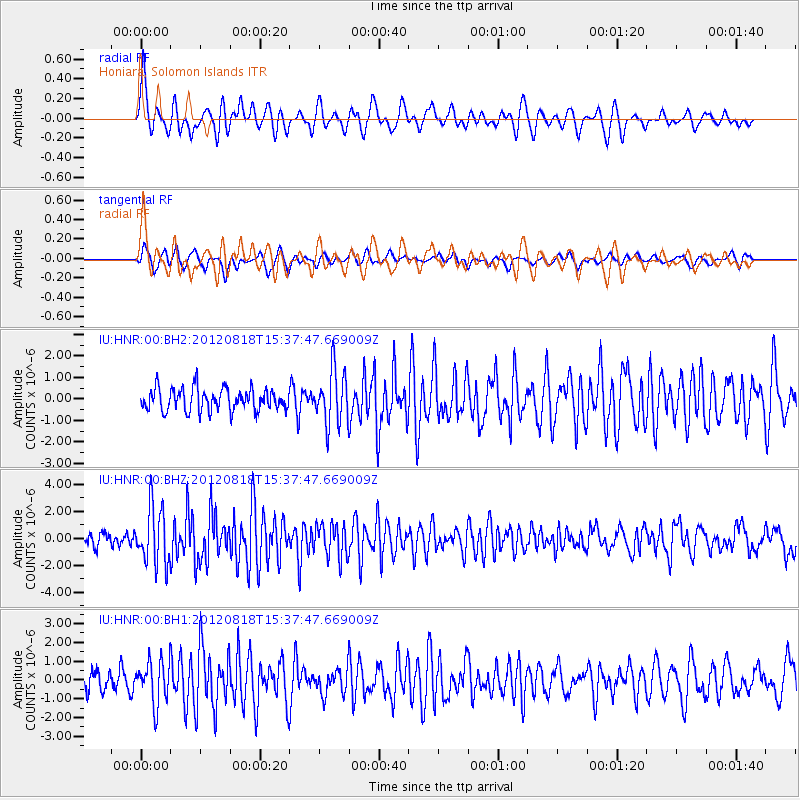
HNR Honiara, Solomon Islands - Earthquake Result Viewer
*The percent match for this event was below the threshold and hence no stack was calculated.
| Earthquake location: |
Halmahera, Indonesia |
| Earthquake latitude/longitude: |
2.6/128.7 |
| Earthquake time(UTC): |
2012/08/18 (231) 15:31:40 GMT |
| Earthquake Depth: |
10 km |
| Earthquake Magnitude: |
5.8 MB, 5.5 MS, 5.8 MW, 5.8 MW |
| Earthquake Catalog/Contributor: |
WHDF/NEIC |
|
| Network: |
IU Global Seismograph Network (GSN - IRIS/USGS) |
| Station: |
HNR Honiara, Solomon Islands |
| Lat/Lon: |
9.44 S/159.95 E |
| Elevation: |
100 m |
|
| Distance: |
33.4 deg |
| Az: |
111.48 deg |
| Baz: |
289.583 deg |
| Ray Param: |
$rayparam |
*The percent match for this event was below the threshold and hence was not used in the summary stack. |
|
| Radial Match: |
75.111664 % |
| Radial Bump: |
400 |
| Transverse Match: |
63.87557 % |
| Transverse Bump: |
400 |
| SOD ConfigId: |
558545 |
| Insert Time: |
2013-09-17 17:30:15.553 +0000 |
| GWidth: |
2.5 |
| Max Bumps: |
400 |
| Tol: |
0.001 |
|
Signal To Noise
| Channel | StoN | STA | LTA |
| IU:HNR:00:BHZ:20120818T15:37:47.669009Z | 4.690665 | 2.1156081E-6 | 4.5102524E-7 |
| IU:HNR:00:BH1:20120818T15:37:47.669009Z | 2.1331651 | 1.1315301E-6 | 5.304465E-7 |
| IU:HNR:00:BH2:20120818T15:37:47.669009Z | 2.409711 | 1.2489187E-6 | 5.182857E-7 |
| Arrivals |
| Ps | |
| PpPs | |
| PsPs/PpSs | |


