You are here: Home > Network List > US - United States National Seismic Network Stations List
> Station EGMT Eagleton, Montana, USA > Earthquake Result Viewer
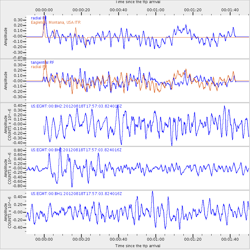
EGMT Eagleton, Montana, USA - Earthquake Result Viewer
*The percent match for this event was below the threshold and hence no stack was calculated.
| Earthquake location: |
Tonga Islands |
| Earthquake latitude/longitude: |
-15.6/-173.0 |
| Earthquake time(UTC): |
2012/08/18 (231) 17:45:02 GMT |
| Earthquake Depth: |
15 km |
| Earthquake Magnitude: |
5.7 MW, 5.4 MS, 5.4 MB, 5.7 MW |
| Earthquake Catalog/Contributor: |
WHDF/NEIC |
|
| Network: |
US United States National Seismic Network |
| Station: |
EGMT Eagleton, Montana, USA |
| Lat/Lon: |
48.02 N/109.75 W |
| Elevation: |
1055 m |
|
| Distance: |
84.7 deg |
| Az: |
37.031 deg |
| Baz: |
239.827 deg |
| Ray Param: |
$rayparam |
*The percent match for this event was below the threshold and hence was not used in the summary stack. |
|
| Radial Match: |
72.73567 % |
| Radial Bump: |
400 |
| Transverse Match: |
53.516045 % |
| Transverse Bump: |
400 |
| SOD ConfigId: |
558545 |
| Insert Time: |
2013-09-17 17:33:52.622 +0000 |
| GWidth: |
2.5 |
| Max Bumps: |
400 |
| Tol: |
0.001 |
|
Signal To Noise
| Channel | StoN | STA | LTA |
| US:EGMT:00:BHZ:20120818T17:57:03.824016Z | 3.9950922 | 2.5637428E-7 | 6.4172305E-8 |
| US:EGMT:00:BH1:20120818T17:57:03.824016Z | 1.2862693 | 1.4178188E-7 | 1.1022721E-7 |
| US:EGMT:00:BH2:20120818T17:57:03.824016Z | 0.743716 | 1.2193838E-7 | 1.6395825E-7 |
| Arrivals |
| Ps | |
| PpPs | |
| PsPs/PpSs | |


