You are here: Home > Network List > IU - Global Seismograph Network (GSN - IRIS/USGS) Stations List
> Station MAKZ Makanchi, Kazakhstan > Earthquake Result Viewer
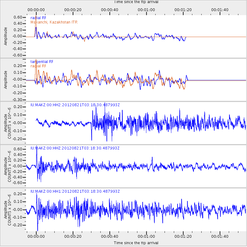
MAKZ Makanchi, Kazakhstan - Earthquake Result Viewer
*The percent match for this event was below the threshold and hence no stack was calculated.
| Earthquake location: |
Southern Sumatra, Indonesia |
| Earthquake latitude/longitude: |
-4.7/103.0 |
| Earthquake time(UTC): |
2012/08/21 (234) 03:09:39 GMT |
| Earthquake Depth: |
66 km |
| Earthquake Magnitude: |
5.5 MB, 5.2 MW |
| Earthquake Catalog/Contributor: |
WHDF/NEIC |
|
| Network: |
IU Global Seismograph Network (GSN - IRIS/USGS) |
| Station: |
MAKZ Makanchi, Kazakhstan |
| Lat/Lon: |
46.81 N/81.98 E |
| Elevation: |
600 m |
|
| Distance: |
54.6 deg |
| Az: |
342.409 deg |
| Baz: |
153.992 deg |
| Ray Param: |
$rayparam |
*The percent match for this event was below the threshold and hence was not used in the summary stack. |
|
| Radial Match: |
68.431595 % |
| Radial Bump: |
400 |
| Transverse Match: |
50.63112 % |
| Transverse Bump: |
400 |
| SOD ConfigId: |
558545 |
| Insert Time: |
2013-09-17 17:42:00.040 +0000 |
| GWidth: |
2.5 |
| Max Bumps: |
400 |
| Tol: |
0.001 |
|
Signal To Noise
| Channel | StoN | STA | LTA |
| IU:MAKZ:00:HHZ:20120821T03:18:30.487993Z | 6.607614 | 2.323774E-7 | 3.5168124E-8 |
| IU:MAKZ:00:HH1:20120821T03:18:30.487993Z | 3.2212546 | 9.0271854E-8 | 2.8023818E-8 |
| IU:MAKZ:00:HH2:20120821T03:18:30.487993Z | 3.5241108 | 6.81465E-8 | 1.9337218E-8 |
| Arrivals |
| Ps | |
| PpPs | |
| PsPs/PpSs | |


