You are here: Home > Network List > IU - Global Seismograph Network (GSN - IRIS/USGS) Stations List
> Station LSZ Lusaka, Zambia > Earthquake Result Viewer
LSZ Lusaka, Zambia - Earthquake Result Viewer

| Earthquake location: |
Java, Indonesia |
| Earthquake latitude/longitude: |
-7.8/107.3 |
| Earthquake time(UTC): |
2009/09/02 (245) 07:55:01 GMT |
| Earthquake Depth: |
46 km |
| Earthquake Magnitude: |
6.8 MB, 7.0 MS, 7.0 MW, 7.0 MW |
| Earthquake Catalog/Contributor: |
WHDF/NEIC |
|
| Network: |
IU Global Seismograph Network (GSN - IRIS/USGS) |
| Station: |
LSZ Lusaka, Zambia |
| Lat/Lon: |
15.28 S/28.19 E |
| Elevation: |
1200 m |
|
| Distance: |
77.5 deg |
| Az: |
256.077 deg |
| Baz: |
94.746 deg |
| Ray Param: |
0.050178736 |
| Estimated Moho Depth: |
45.5 km |
| Estimated Crust Vp/Vs: |
1.63 |
| Assumed Crust Vp: |
6.642 km/s |
| Estimated Crust Vs: |
4.069 km/s |
| Estimated Crust Poisson's Ratio: |
0.20 |
|
| Radial Match: |
97.45896 % |
| Radial Bump: |
364 |
| Transverse Match: |
90.30469 % |
| Transverse Bump: |
400 |
| SOD ConfigId: |
1 |
| Insert Time: |
2010-02-19 00:05:03.042 +0000 |
| GWidth: |
2.5 |
| Max Bumps: |
400 |
| Tol: |
0.001 |
|
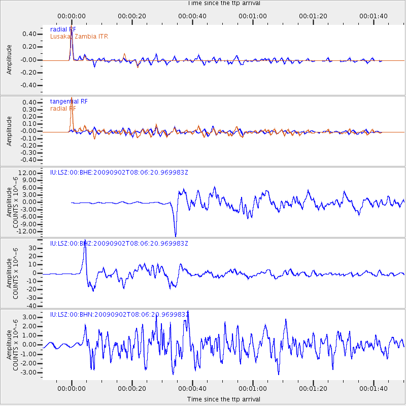
Signal To Noise
| Channel | StoN | STA | LTA |
| IU:LSZ:00:BHZ:20090902T08:06:20.969983Z | 50.628708 | 1.3964717E-5 | 2.7582607E-7 |
| IU:LSZ:00:BHN:20090902T08:06:20.969983Z | 4.227552 | 6.8973327E-7 | 1.6315194E-7 |
| IU:LSZ:00:BHE:20090902T08:06:20.969983Z | 23.896076 | 4.795098E-6 | 2.0066466E-7 |
| Arrivals |
| Ps | 4.5 SECOND |
| PpPs | 17 SECOND |
| PsPs/PpSs | 22 SECOND |


