You are here: Home > Network List > US - United States National Seismic Network Stations List
> Station HAWA Hanford, Washington, USA > Earthquake Result Viewer
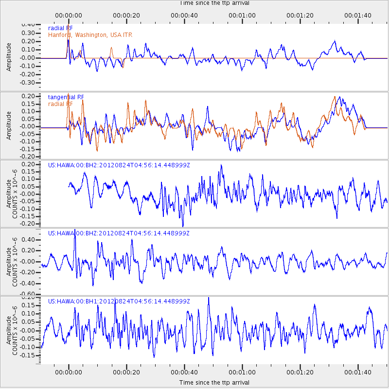
HAWA Hanford, Washington, USA - Earthquake Result Viewer
*The percent match for this event was below the threshold and hence no stack was calculated.
| Earthquake location: |
Kermadec Islands Region |
| Earthquake latitude/longitude: |
-27.3/-176.8 |
| Earthquake time(UTC): |
2012/08/24 (237) 04:43:48 GMT |
| Earthquake Depth: |
16 km |
| Earthquake Magnitude: |
5.7 MW, 5.5 MB, 5.7 MW |
| Earthquake Catalog/Contributor: |
NEIC PDE/NEIC PDE-W |
|
| Network: |
US United States National Seismic Network |
| Station: |
HAWA Hanford, Washington, USA |
| Lat/Lon: |
46.39 N/119.53 W |
| Elevation: |
364 m |
|
| Distance: |
89.8 deg |
| Az: |
35.611 deg |
| Baz: |
228.465 deg |
| Ray Param: |
$rayparam |
*The percent match for this event was below the threshold and hence was not used in the summary stack. |
|
| Radial Match: |
60.268764 % |
| Radial Bump: |
400 |
| Transverse Match: |
44.91132 % |
| Transverse Bump: |
400 |
| SOD ConfigId: |
558545 |
| Insert Time: |
2013-09-17 17:47:10.486 +0000 |
| GWidth: |
2.5 |
| Max Bumps: |
400 |
| Tol: |
0.001 |
|
Signal To Noise
| Channel | StoN | STA | LTA |
| US:HAWA:00:BHZ:20120824T04:56:14.448999Z | 3.4219809 | 1.9713723E-7 | 5.76091E-8 |
| US:HAWA:00:BH1:20120824T04:56:14.448999Z | 1.1457195 | 6.122236E-8 | 5.343573E-8 |
| US:HAWA:00:BH2:20120824T04:56:14.448999Z | 1.5910873 | 9.2248094E-8 | 5.7978024E-8 |
| Arrivals |
| Ps | |
| PpPs | |
| PsPs/PpSs | |


