You are here: Home > Network List > UW - Pacific Northwest Regional Seismic Network Stations List
> Station UMAT Pilot Rock, OR, USA > Earthquake Result Viewer
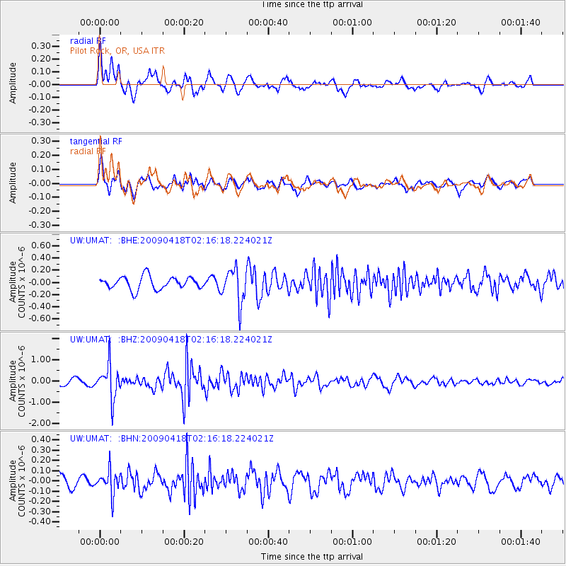
UMAT Pilot Rock, OR, USA - Earthquake Result Viewer
*The percent match for this event was below the threshold and hence no stack was calculated.
| Earthquake location: |
Kermadec Islands Region |
| Earthquake latitude/longitude: |
-28.9/-177.4 |
| Earthquake time(UTC): |
2009/04/18 (108) 02:03:52 GMT |
| Earthquake Depth: |
65 km |
| Earthquake Magnitude: |
6.0 MB, 5.8 MW, 5.7 MW |
| Earthquake Catalog/Contributor: |
WHDF/NEIC |
|
| Network: |
UW Pacific Northwest Regional Seismic Network |
| Station: |
UMAT Pilot Rock, OR, USA |
| Lat/Lon: |
45.29 N/118.96 W |
| Elevation: |
1318 m |
|
| Distance: |
91.0 deg |
| Az: |
37.004 deg |
| Baz: |
228.375 deg |
| Ray Param: |
$rayparam |
*The percent match for this event was below the threshold and hence was not used in the summary stack. |
|
| Radial Match: |
75.10313 % |
| Radial Bump: |
400 |
| Transverse Match: |
64.434265 % |
| Transverse Bump: |
400 |
| SOD ConfigId: |
2760 |
| Insert Time: |
2010-02-27 05:16:21.429 +0000 |
| GWidth: |
2.5 |
| Max Bumps: |
400 |
| Tol: |
0.001 |
|
Signal To Noise
| Channel | StoN | STA | LTA |
| UW:UMAT: :BHZ:20090418T02:16:18.224021Z | 5.7079935 | 8.158076E-7 | 1.4292371E-7 |
| UW:UMAT: :BHN:20090418T02:16:18.224021Z | 1.349679 | 1.18169574E-7 | 8.7553836E-8 |
| UW:UMAT: :BHE:20090418T02:16:18.224021Z | 2.728285 | 2.830854E-7 | 1.0375947E-7 |
| Arrivals |
| Ps | |
| PpPs | |
| PsPs/PpSs | |


