You are here: Home > Network List > IU - Global Seismograph Network (GSN - IRIS/USGS) Stations List
> Station GNI Garni, Armenia > Earthquake Result Viewer
GNI Garni, Armenia - Earthquake Result Viewer
| Earthquake location: |
Hokkaido, Japan Region |
| Earthquake latitude/longitude: |
42.4/142.9 |
| Earthquake time(UTC): |
2012/08/25 (238) 14:16:17 GMT |
| Earthquake Depth: |
54 km |
| Earthquake Magnitude: |
5.9 MW, 5.9 MB, 5.9 MW |
| Earthquake Catalog/Contributor: |
NEIC PDE/NEIC PDE-W |
|
| Network: |
IU Global Seismograph Network (GSN - IRIS/USGS) |
| Station: |
GNI Garni, Armenia |
| Lat/Lon: |
40.15 N/44.74 E |
| Elevation: |
1609 m |
|
| Distance: |
69.5 deg |
| Az: |
305.878 deg |
| Baz: |
51.513 deg |
| Ray Param: |
0.05552189 |
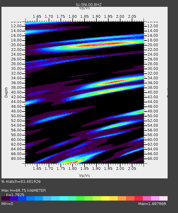
| Estimated Moho Depth: |
69.75 km |
| Estimated Crust Vp/Vs: |
1.79 |
| Assumed Crust Vp: |
6.291 km/s |
| Estimated Crust Vs: |
3.509 km/s |
| Estimated Crust Poisson's Ratio: |
0.27 |
|
| Radial Match: |
83.481926 % |
| Radial Bump: |
400 |
| Transverse Match: |
79.50631 % |
| Transverse Bump: |
400 |
| SOD ConfigId: |
558545 |
| Insert Time: |
2013-09-17 17:52:41.283 +0000 |
| GWidth: |
2.5 |
| Max Bumps: |
400 |
| Tol: |
0.001 |
|
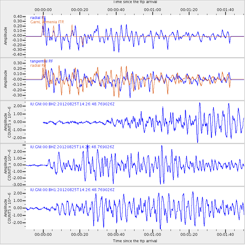
Signal To Noise
| Channel | StoN | STA | LTA |
| IU:GNI:00:BHZ:20120825T14:26:48.769026Z | 5.5645614 | 3.339485E-7 | 6.001344E-8 |
| IU:GNI:00:BH1:20120825T14:26:48.769026Z | 1.4381902 | 1.2314561E-7 | 8.56254E-8 |
| IU:GNI:00:BH2:20120825T14:26:48.769026Z | 1.337239 | 1.2140335E-7 | 9.078657E-8 |
| Arrivals |
| Ps | 9.1 SECOND |
| PpPs | 30 SECOND |
| PsPs/PpSs | 39 SECOND |


