You are here: Home > Network List > IU - Global Seismograph Network (GSN - IRIS/USGS) Stations List
> Station JOHN Johnston Island, USA > Earthquake Result Viewer
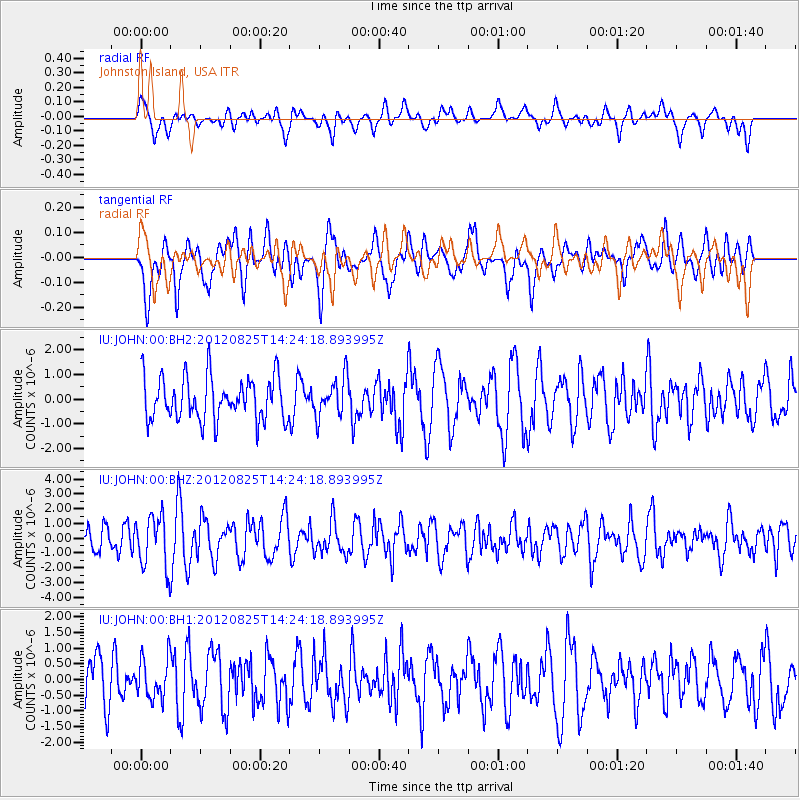
JOHN Johnston Island, USA - Earthquake Result Viewer
*The percent match for this event was below the threshold and hence no stack was calculated.
| Earthquake location: |
Hokkaido, Japan Region |
| Earthquake latitude/longitude: |
42.4/142.9 |
| Earthquake time(UTC): |
2012/08/25 (238) 14:16:17 GMT |
| Earthquake Depth: |
54 km |
| Earthquake Magnitude: |
5.9 MW, 5.9 MB, 5.9 MW |
| Earthquake Catalog/Contributor: |
NEIC PDE/NEIC PDE-W |
|
| Network: |
IU Global Seismograph Network (GSN - IRIS/USGS) |
| Station: |
JOHN Johnston Island, USA |
| Lat/Lon: |
16.73 N/169.53 W |
| Elevation: |
2.0 m |
|
| Distance: |
47.8 deg |
| Az: |
107.482 deg |
| Baz: |
312.515 deg |
| Ray Param: |
$rayparam |
*The percent match for this event was below the threshold and hence was not used in the summary stack. |
|
| Radial Match: |
47.75996 % |
| Radial Bump: |
400 |
| Transverse Match: |
60.642616 % |
| Transverse Bump: |
400 |
| SOD ConfigId: |
558545 |
| Insert Time: |
2013-09-17 17:52:48.567 +0000 |
| GWidth: |
2.5 |
| Max Bumps: |
400 |
| Tol: |
0.001 |
|
Signal To Noise
| Channel | StoN | STA | LTA |
| IU:JOHN:00:BHZ:20120825T14:24:18.893995Z | 2.0329614 | 1.7688241E-6 | 8.7007265E-7 |
| IU:JOHN:00:BH1:20120825T14:24:18.893995Z | 0.8907059 | 6.3949994E-7 | 7.1796984E-7 |
| IU:JOHN:00:BH2:20120825T14:24:18.893995Z | 0.9171316 | 8.0057976E-7 | 8.72917E-7 |
| Arrivals |
| Ps | |
| PpPs | |
| PsPs/PpSs | |


