You are here: Home > Network List > US - United States National Seismic Network Stations List
> Station COWI Conover, Wisconsin, USA > Earthquake Result Viewer
COWI Conover, Wisconsin, USA - Earthquake Result Viewer

| Earthquake location: |
Hokkaido, Japan Region |
| Earthquake latitude/longitude: |
42.4/142.9 |
| Earthquake time(UTC): |
2012/08/25 (238) 14:16:17 GMT |
| Earthquake Depth: |
54 km |
| Earthquake Magnitude: |
5.9 MW, 5.9 MB, 5.9 MW |
| Earthquake Catalog/Contributor: |
NEIC PDE/NEIC PDE-W |
|
| Network: |
US United States National Seismic Network |
| Station: |
COWI Conover, Wisconsin, USA |
| Lat/Lon: |
46.10 N/89.14 W |
| Elevation: |
523 m |
|
| Distance: |
80.5 deg |
| Az: |
33.806 deg |
| Baz: |
323.693 deg |
| Ray Param: |
0.048166152 |
| Estimated Moho Depth: |
47.0 km |
| Estimated Crust Vp/Vs: |
1.65 |
| Assumed Crust Vp: |
6.467 km/s |
| Estimated Crust Vs: |
3.907 km/s |
| Estimated Crust Poisson's Ratio: |
0.21 |
|
| Radial Match: |
90.27341 % |
| Radial Bump: |
400 |
| Transverse Match: |
74.35969 % |
| Transverse Bump: |
400 |
| SOD ConfigId: |
558545 |
| Insert Time: |
2013-09-17 17:54:31.505 +0000 |
| GWidth: |
2.5 |
| Max Bumps: |
400 |
| Tol: |
0.001 |
|
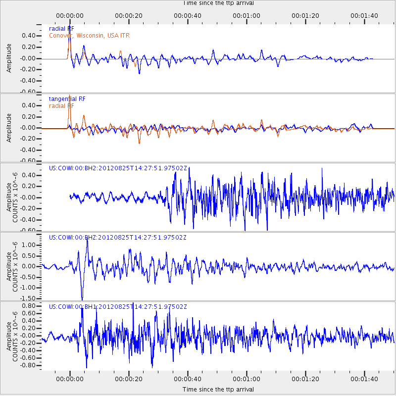
Signal To Noise
| Channel | StoN | STA | LTA |
| US:COWI:00:BHZ:20120825T14:27:51.97502Z | 9.436394 | 5.463435E-7 | 5.7897484E-8 |
| US:COWI:00:BH1:20120825T14:27:51.97502Z | 4.990889 | 2.413421E-7 | 4.8356537E-8 |
| US:COWI:00:BH2:20120825T14:27:51.97502Z | 3.0144277 | 1.4943973E-7 | 4.9574826E-8 |
| Arrivals |
| Ps | 4.9 SECOND |
| PpPs | 19 SECOND |
| PsPs/PpSs | 24 SECOND |


