You are here: Home > Network List > UW - Pacific Northwest Regional Seismic Network Stations List
> Station UMAT Pilot Rock, OR, USA > Earthquake Result Viewer
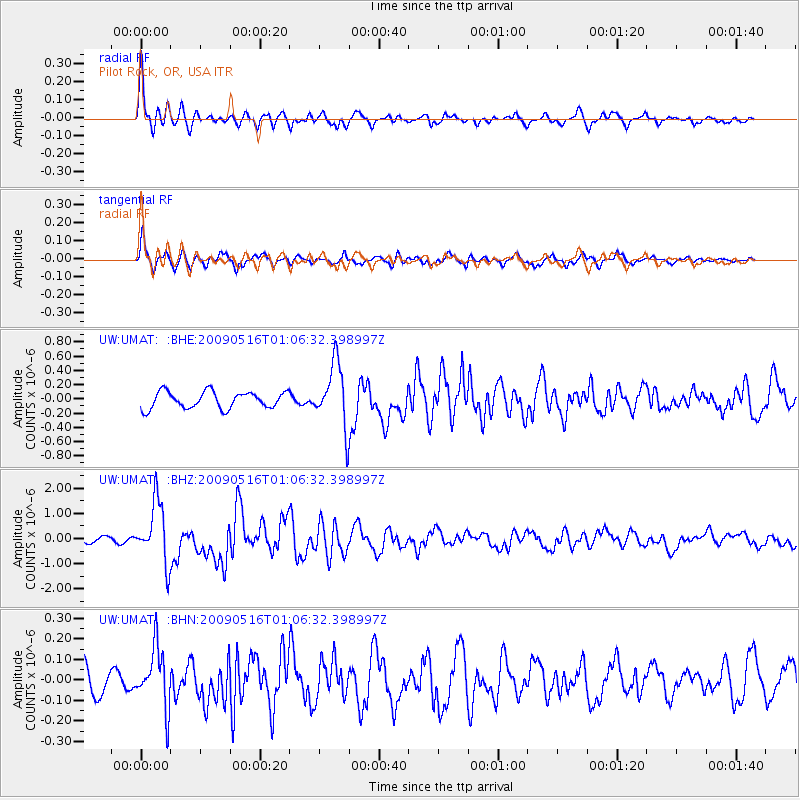
UMAT Pilot Rock, OR, USA - Earthquake Result Viewer
*The percent match for this event was below the threshold and hence no stack was calculated.
| Earthquake location: |
Kermadec Islands Region |
| Earthquake latitude/longitude: |
-31.5/-178.8 |
| Earthquake time(UTC): |
2009/05/16 (136) 00:53:52 GMT |
| Earthquake Depth: |
55 km |
| Earthquake Magnitude: |
6.1 MB, 6.5 MW, 6.3 MW |
| Earthquake Catalog/Contributor: |
WHDF/NEIC |
|
| Network: |
UW Pacific Northwest Regional Seismic Network |
| Station: |
UMAT Pilot Rock, OR, USA |
| Lat/Lon: |
45.29 N/118.96 W |
| Elevation: |
1318 m |
|
| Distance: |
93.8 deg |
| Az: |
37.706 deg |
| Baz: |
227.727 deg |
| Ray Param: |
$rayparam |
*The percent match for this event was below the threshold and hence was not used in the summary stack. |
|
| Radial Match: |
84.94032 % |
| Radial Bump: |
400 |
| Transverse Match: |
79.593925 % |
| Transverse Bump: |
400 |
| SOD ConfigId: |
2760 |
| Insert Time: |
2010-02-27 05:16:33.887 +0000 |
| GWidth: |
2.5 |
| Max Bumps: |
400 |
| Tol: |
0.001 |
|
Signal To Noise
| Channel | StoN | STA | LTA |
| UW:UMAT: :BHZ:20090516T01:06:32.398997Z | 14.260257 | 1.2106896E-6 | 8.489956E-8 |
| UW:UMAT: :BHN:20090516T01:06:32.398997Z | 1.8042464 | 1.4668804E-7 | 8.130155E-8 |
| UW:UMAT: :BHE:20090516T01:06:32.398997Z | 3.7986846 | 4.4388423E-7 | 1.1685209E-7 |
| Arrivals |
| Ps | |
| PpPs | |
| PsPs/PpSs | |


