You are here: Home > Network List > US - United States National Seismic Network Stations List
> Station WMOK Wichita Mountains, Oklahoma, USA > Earthquake Result Viewer
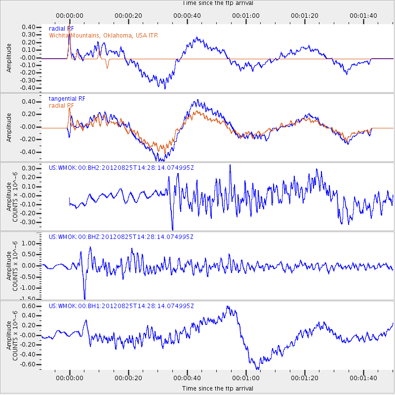
WMOK Wichita Mountains, Oklahoma, USA - Earthquake Result Viewer
*The percent match for this event was below the threshold and hence no stack was calculated.
| Earthquake location: |
Hokkaido, Japan Region |
| Earthquake latitude/longitude: |
42.4/142.9 |
| Earthquake time(UTC): |
2012/08/25 (238) 14:16:17 GMT |
| Earthquake Depth: |
54 km |
| Earthquake Magnitude: |
5.9 MW, 5.9 MB, 5.9 MW |
| Earthquake Catalog/Contributor: |
NEIC PDE/NEIC PDE-W |
|
| Network: |
US United States National Seismic Network |
| Station: |
WMOK Wichita Mountains, Oklahoma, USA |
| Lat/Lon: |
34.74 N/98.78 W |
| Elevation: |
486 m |
|
| Distance: |
84.7 deg |
| Az: |
46.733 deg |
| Baz: |
319.101 deg |
| Ray Param: |
$rayparam |
*The percent match for this event was below the threshold and hence was not used in the summary stack. |
|
| Radial Match: |
65.38911 % |
| Radial Bump: |
400 |
| Transverse Match: |
61.82706 % |
| Transverse Bump: |
400 |
| SOD ConfigId: |
558545 |
| Insert Time: |
2013-09-17 17:56:35.805 +0000 |
| GWidth: |
2.5 |
| Max Bumps: |
400 |
| Tol: |
0.001 |
|
Signal To Noise
| Channel | StoN | STA | LTA |
| US:WMOK:00:BHZ:20120825T14:28:14.074995Z | 6.022044 | 2.695418E-7 | 4.4759187E-8 |
| US:WMOK:00:BH1:20120825T14:28:14.074995Z | 1.0507159 | 1.3903892E-7 | 1.323278E-7 |
| US:WMOK:00:BH2:20120825T14:28:14.074995Z | 1.9287887 | 1.0183576E-7 | 5.279778E-8 |
| Arrivals |
| Ps | |
| PpPs | |
| PsPs/PpSs | |


