You are here: Home > Network List > US - United States National Seismic Network Stations List
> Station AMTX Amarillo, Texas, USA > Earthquake Result Viewer
AMTX Amarillo, Texas, USA - Earthquake Result Viewer
*The percent match for this event was below the threshold and hence no stack was calculated.
| Earthquake location: |
Central East Pacific Rise |
| Earthquake latitude/longitude: |
-4.6/-105.9 |
| Earthquake time(UTC): |
2012/09/06 (250) 23:33:06 GMT |
| Earthquake Depth: |
10 km |
| Earthquake Magnitude: |
5.8 MW, 5.5 MS, 5.7 MW |
| Earthquake Catalog/Contributor: |
NEIC PDE/NEIC PDE-W |
|
| Network: |
US United States National Seismic Network |
| Station: |
AMTX Amarillo, Texas, USA |
| Lat/Lon: |
34.53 N/101.41 W |
| Elevation: |
1010 m |
|
| Distance: |
39.1 deg |
| Az: |
5.866 deg |
| Baz: |
187.088 deg |
| Ray Param: |
$rayparam |
*The percent match for this event was below the threshold and hence was not used in the summary stack. |
|
| Radial Match: |
52.702553 % |
| Radial Bump: |
400 |
| Transverse Match: |
51.812813 % |
| Transverse Bump: |
400 |
| SOD ConfigId: |
558545 |
| Insert Time: |
2013-09-17 18:00:12.479 +0000 |
| GWidth: |
2.5 |
| Max Bumps: |
400 |
| Tol: |
0.001 |
|
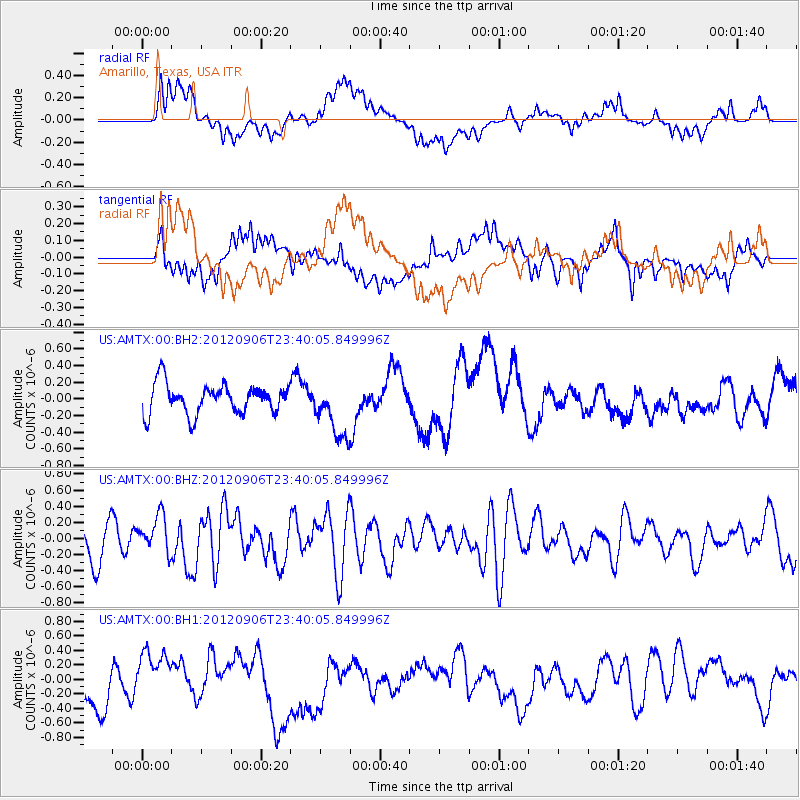
Signal To Noise
| Channel | StoN | STA | LTA |
| US:AMTX:00:BHZ:20120906T23:40:05.849996Z | 1.1082739 | 2.3276114E-7 | 2.1002131E-7 |
| US:AMTX:00:BH1:20120906T23:40:05.849996Z | 0.99564624 | 2.7638728E-7 | 2.7759586E-7 |
| US:AMTX:00:BH2:20120906T23:40:05.849996Z | 0.9061148 | 1.6861277E-7 | 1.8608324E-7 |
| Arrivals |
| Ps | |
| PpPs | |
| PsPs/PpSs | |


