You are here: Home > Network List > UW - Pacific Northwest Regional Seismic Network Stations List
> Station UMAT Pilot Rock, OR, USA > Earthquake Result Viewer
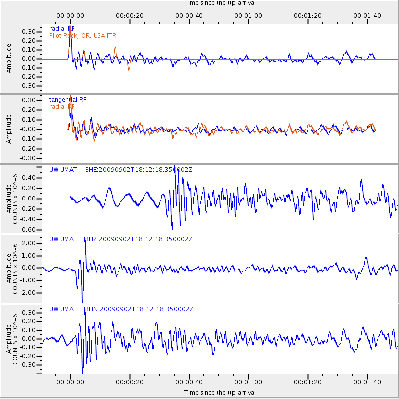
UMAT Pilot Rock, OR, USA - Earthquake Result Viewer
*The percent match for this event was below the threshold and hence no stack was calculated.
| Earthquake location: |
Kermadec Islands, New Zealand |
| Earthquake latitude/longitude: |
-29.4/-179.0 |
| Earthquake time(UTC): |
2009/09/02 (245) 18:00:11 GMT |
| Earthquake Depth: |
275 km |
| Earthquake Magnitude: |
5.8 MB, 6.2 MW, 6.1 MW |
| Earthquake Catalog/Contributor: |
WHDF/NEIC |
|
| Network: |
UW Pacific Northwest Regional Seismic Network |
| Station: |
UMAT Pilot Rock, OR, USA |
| Lat/Lon: |
45.29 N/118.96 W |
| Elevation: |
1318 m |
|
| Distance: |
92.1 deg |
| Az: |
37.715 deg |
| Baz: |
229.161 deg |
| Ray Param: |
$rayparam |
*The percent match for this event was below the threshold and hence was not used in the summary stack. |
|
| Radial Match: |
73.62524 % |
| Radial Bump: |
400 |
| Transverse Match: |
64.47196 % |
| Transverse Bump: |
400 |
| SOD ConfigId: |
2622 |
| Insert Time: |
2010-02-27 05:16:42.673 +0000 |
| GWidth: |
2.5 |
| Max Bumps: |
400 |
| Tol: |
0.001 |
|
Signal To Noise
| Channel | StoN | STA | LTA |
| UW:UMAT: :BHZ:20090902T18:12:18.350002Z | 12.124136 | 1.0224346E-6 | 8.433051E-8 |
| UW:UMAT: :BHN:20090902T18:12:18.350002Z | 2.2100868 | 1.4409123E-7 | 6.519709E-8 |
| UW:UMAT: :BHE:20090902T18:12:18.350002Z | 2.602916 | 2.078704E-7 | 7.986059E-8 |
| Arrivals |
| Ps | |
| PpPs | |
| PsPs/PpSs | |


