You are here: Home > Network List > UW - Pacific Northwest Regional Seismic Network Stations List
> Station UMAT Pilot Rock, OR, USA > Earthquake Result Viewer
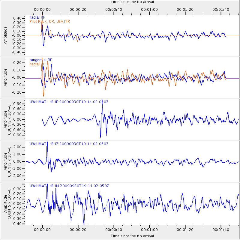
UMAT Pilot Rock, OR, USA - Earthquake Result Viewer
*The percent match for this event was below the threshold and hence no stack was calculated.
| Earthquake location: |
Peru-Bolivia Border Region |
| Earthquake latitude/longitude: |
-15.6/-69.3 |
| Earthquake time(UTC): |
2009/09/30 (273) 19:03:17 GMT |
| Earthquake Depth: |
255 km |
| Earthquake Magnitude: |
5.9 MB, 5.8 MW |
| Earthquake Catalog/Contributor: |
WHDF/NEIC |
|
| Network: |
UW Pacific Northwest Regional Seismic Network |
| Station: |
UMAT Pilot Rock, OR, USA |
| Lat/Lon: |
45.29 N/118.96 W |
| Elevation: |
1318 m |
|
| Distance: |
75.4 deg |
| Az: |
326.221 deg |
| Baz: |
130.609 deg |
| Ray Param: |
$rayparam |
*The percent match for this event was below the threshold and hence was not used in the summary stack. |
|
| Radial Match: |
64.48431 % |
| Radial Bump: |
400 |
| Transverse Match: |
74.185844 % |
| Transverse Bump: |
400 |
| SOD ConfigId: |
2622 |
| Insert Time: |
2010-02-27 05:16:53.172 +0000 |
| GWidth: |
2.5 |
| Max Bumps: |
400 |
| Tol: |
0.001 |
|
Signal To Noise
| Channel | StoN | STA | LTA |
| UW:UMAT: :BHZ:20090930T19:14:02.050Z | 6.2641015 | 8.5630535E-7 | 1.3670044E-7 |
| UW:UMAT: :BHN:20090930T19:14:02.050Z | 1.7281673 | 1.606817E-7 | 9.297809E-8 |
| UW:UMAT: :BHE:20090930T19:14:02.050Z | 3.2384863 | 4.1505976E-7 | 1.2816474E-7 |
| Arrivals |
| Ps | |
| PpPs | |
| PsPs/PpSs | |


