You are here: Home > Network List > TA - USArray Transportable Network (new EarthScope stations) Stations List
> Station W41B Gary Mavity, Velonia, AR, USA > Earthquake Result Viewer
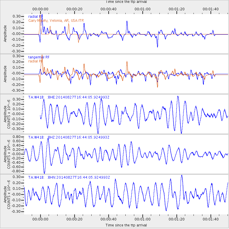
W41B Gary Mavity, Velonia, AR, USA - Earthquake Result Viewer
*The percent match for this event was below the threshold and hence no stack was calculated.
| Earthquake location: |
Fiji Islands Region |
| Earthquake latitude/longitude: |
-15.6/-177.8 |
| Earthquake time(UTC): |
2014/08/27 (239) 16:31:13 GMT |
| Earthquake Depth: |
10 km |
| Earthquake Magnitude: |
5.7 Mwc, 5.4 mb, 5.3 Ms_20, 5.6 Mwb |
| Earthquake Catalog/Contributor: |
ISC/ISC |
|
| Network: |
TA USArray Transportable Network (new EarthScope stations) |
| Station: |
W41B Gary Mavity, Velonia, AR, USA |
| Lat/Lon: |
35.17 N/92.25 W |
| Elevation: |
95 m |
|
| Distance: |
95.3 deg |
| Az: |
55.113 deg |
| Baz: |
254.801 deg |
| Ray Param: |
$rayparam |
*The percent match for this event was below the threshold and hence was not used in the summary stack. |
|
| Radial Match: |
68.53635 % |
| Radial Bump: |
400 |
| Transverse Match: |
57.943363 % |
| Transverse Bump: |
392 |
| SOD ConfigId: |
3390531 |
| Insert Time: |
2019-04-13 16:10:23.680 +0000 |
| GWidth: |
2.5 |
| Max Bumps: |
400 |
| Tol: |
0.001 |
|
Signal To Noise
| Channel | StoN | STA | LTA |
| TA:W41B: :BHZ:20140827T16:44:05.924993Z | 2.7455547 | 5.265376E-7 | 1.9177821E-7 |
| TA:W41B: :BHN:20140827T16:44:05.924993Z | 0.97085184 | 9.537138E-8 | 9.8234736E-8 |
| TA:W41B: :BHE:20140827T16:44:05.924993Z | 1.6961057 | 2.1283768E-7 | 1.2548608E-7 |
| Arrivals |
| Ps | |
| PpPs | |
| PsPs/PpSs | |


