You are here: Home > Network List > UW - Pacific Northwest Regional Seismic Network Stations List
> Station UMAT Pilot Rock, OR, USA > Earthquake Result Viewer
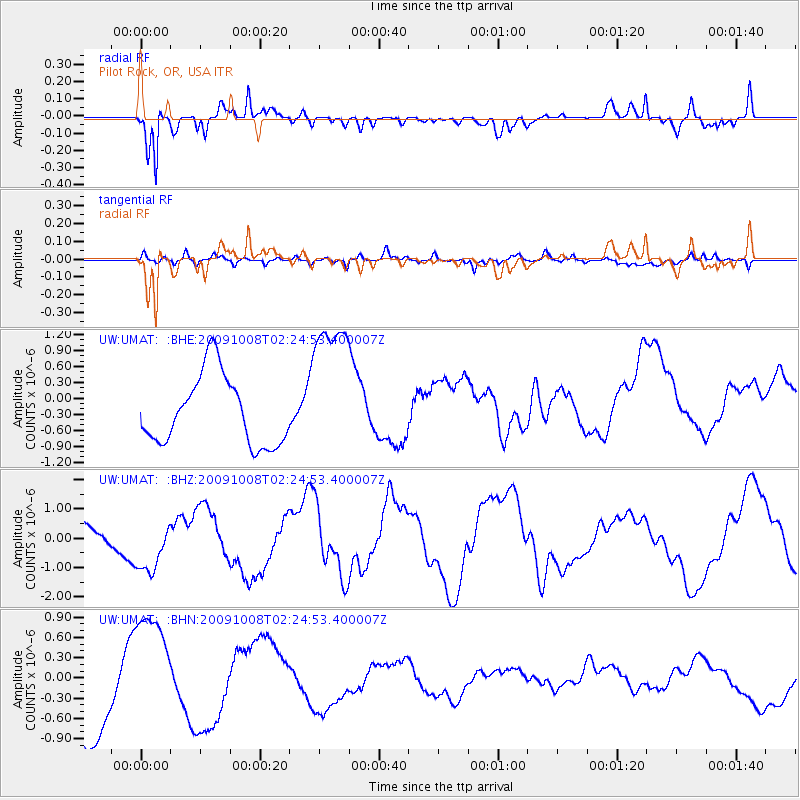
UMAT Pilot Rock, OR, USA - Earthquake Result Viewer
*The percent match for this event was below the threshold and hence no stack was calculated.
| Earthquake location: |
Santa Cruz Islands |
| Earthquake latitude/longitude: |
-11.7/166.2 |
| Earthquake time(UTC): |
2009/10/08 (281) 02:12:39 GMT |
| Earthquake Depth: |
35 km |
| Earthquake Magnitude: |
5.8 MB, 6.6 MW |
| Earthquake Catalog/Contributor: |
WHDF/NEIC |
|
| Network: |
UW Pacific Northwest Regional Seismic Network |
| Station: |
UMAT Pilot Rock, OR, USA |
| Lat/Lon: |
45.29 N/118.96 W |
| Elevation: |
1318 m |
|
| Distance: |
87.8 deg |
| Az: |
42.993 deg |
| Baz: |
251.145 deg |
| Ray Param: |
$rayparam |
*The percent match for this event was below the threshold and hence was not used in the summary stack. |
|
| Radial Match: |
75.655716 % |
| Radial Bump: |
388 |
| Transverse Match: |
46.280357 % |
| Transverse Bump: |
367 |
| SOD ConfigId: |
2622 |
| Insert Time: |
2010-02-27 05:16:56.072 +0000 |
| GWidth: |
2.5 |
| Max Bumps: |
400 |
| Tol: |
0.001 |
|
Signal To Noise
| Channel | StoN | STA | LTA |
| UW:UMAT: :BHZ:20091008T02:24:53.400007Z | 1.7452579 | 9.589355E-7 | 5.49452E-7 |
| UW:UMAT: :BHN:20091008T02:24:53.400007Z | 1.3517523 | 9.21155E-7 | 6.8145255E-7 |
| UW:UMAT: :BHE:20091008T02:24:53.400007Z | 2.2090845 | 1.4420998E-6 | 6.5280426E-7 |
| Arrivals |
| Ps | |
| PpPs | |
| PsPs/PpSs | |


