You are here: Home > Network List > IU - Global Seismograph Network (GSN - IRIS/USGS) Stations List
> Station TEIG Tepich, Yucatan, Mexico > Earthquake Result Viewer
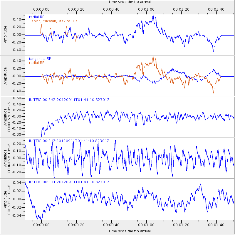
TEIG Tepich, Yucatan, Mexico - Earthquake Result Viewer
*The percent match for this event was below the threshold and hence no stack was calculated.
| Earthquake location: |
Kuril Islands |
| Earthquake latitude/longitude: |
45.3/151.1 |
| Earthquake time(UTC): |
2012/09/11 (255) 01:28:18 GMT |
| Earthquake Depth: |
14 km |
| Earthquake Magnitude: |
5.6 MW, 5.5 MW |
| Earthquake Catalog/Contributor: |
NEIC PDE/NEIC PDE-W |
|
| Network: |
IU Global Seismograph Network (GSN - IRIS/USGS) |
| Station: |
TEIG Tepich, Yucatan, Mexico |
| Lat/Lon: |
20.23 N/88.28 W |
| Elevation: |
40 m |
|
| Distance: |
95.4 deg |
| Az: |
54.269 deg |
| Baz: |
322.431 deg |
| Ray Param: |
$rayparam |
*The percent match for this event was below the threshold and hence was not used in the summary stack. |
|
| Radial Match: |
32.217915 % |
| Radial Bump: |
400 |
| Transverse Match: |
20.19346 % |
| Transverse Bump: |
400 |
| SOD ConfigId: |
558545 |
| Insert Time: |
2013-09-17 18:25:46.126 +0000 |
| GWidth: |
2.5 |
| Max Bumps: |
400 |
| Tol: |
0.001 |
|
Signal To Noise
| Channel | StoN | STA | LTA |
| IU:TEIG:00:BHZ:20120911T01:41:10.82301Z | 0.77877855 | 8.6380375E-8 | 1.1091776E-7 |
| IU:TEIG:00:BH1:20120911T01:41:10.82301Z | 0.19850042 | 1.7914651E-8 | 9.024994E-8 |
| IU:TEIG:00:BH2:20120911T01:41:10.82301Z | 0.97276515 | 1.7793735E-7 | 1.8291912E-7 |
| Arrivals |
| Ps | |
| PpPs | |
| PsPs/PpSs | |


