You are here: Home > Network List > UW - Pacific Northwest Regional Seismic Network Stations List
> Station UMAT Pilot Rock, OR, USA > Earthquake Result Viewer
UMAT Pilot Rock, OR, USA - Earthquake Result Viewer
*The percent match for this event was below the threshold and hence no stack was calculated.
| Earthquake location: |
Azores Islands Region |
| Earthquake latitude/longitude: |
36.2/-33.9 |
| Earthquake time(UTC): |
2009/11/04 (308) 18:41:44 GMT |
| Earthquake Depth: |
10 km |
| Earthquake Magnitude: |
5.7 MB, 5.6 MS, 5.9 MW, 5.8 MW |
| Earthquake Catalog/Contributor: |
WHDF/NEIC |
|
| Network: |
UW Pacific Northwest Regional Seismic Network |
| Station: |
UMAT Pilot Rock, OR, USA |
| Lat/Lon: |
45.29 N/118.96 W |
| Elevation: |
1318 m |
|
| Distance: |
62.3 deg |
| Az: |
307.401 deg |
| Baz: |
65.615 deg |
| Ray Param: |
$rayparam |
*The percent match for this event was below the threshold and hence was not used in the summary stack. |
|
| Radial Match: |
69.97438 % |
| Radial Bump: |
400 |
| Transverse Match: |
72.867714 % |
| Transverse Bump: |
400 |
| SOD ConfigId: |
2622 |
| Insert Time: |
2010-02-27 05:17:35.811 +0000 |
| GWidth: |
2.5 |
| Max Bumps: |
400 |
| Tol: |
0.001 |
|
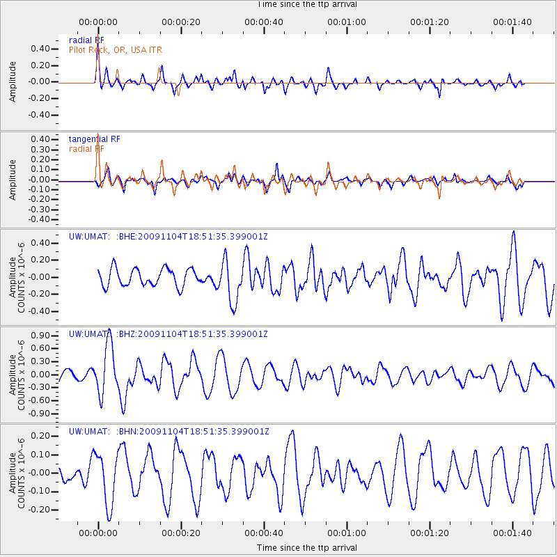
Signal To Noise
| Channel | StoN | STA | LTA |
| UW:UMAT: :BHZ:20091104T18:51:35.399001Z | 4.763802 | 5.8489445E-7 | 1.2277893E-7 |
| UW:UMAT: :BHN:20091104T18:51:35.399001Z | 4.2094755 | 1.4264755E-7 | 3.388725E-8 |
| UW:UMAT: :BHE:20091104T18:51:35.399001Z | 2.4470217 | 2.463554E-7 | 1.00675614E-7 |
| Arrivals |
| Ps | |
| PpPs | |
| PsPs/PpSs | |


