You are here: Home > Network List > UW - Pacific Northwest Regional Seismic Network Stations List
> Station UMAT Pilot Rock, OR, USA > Earthquake Result Viewer
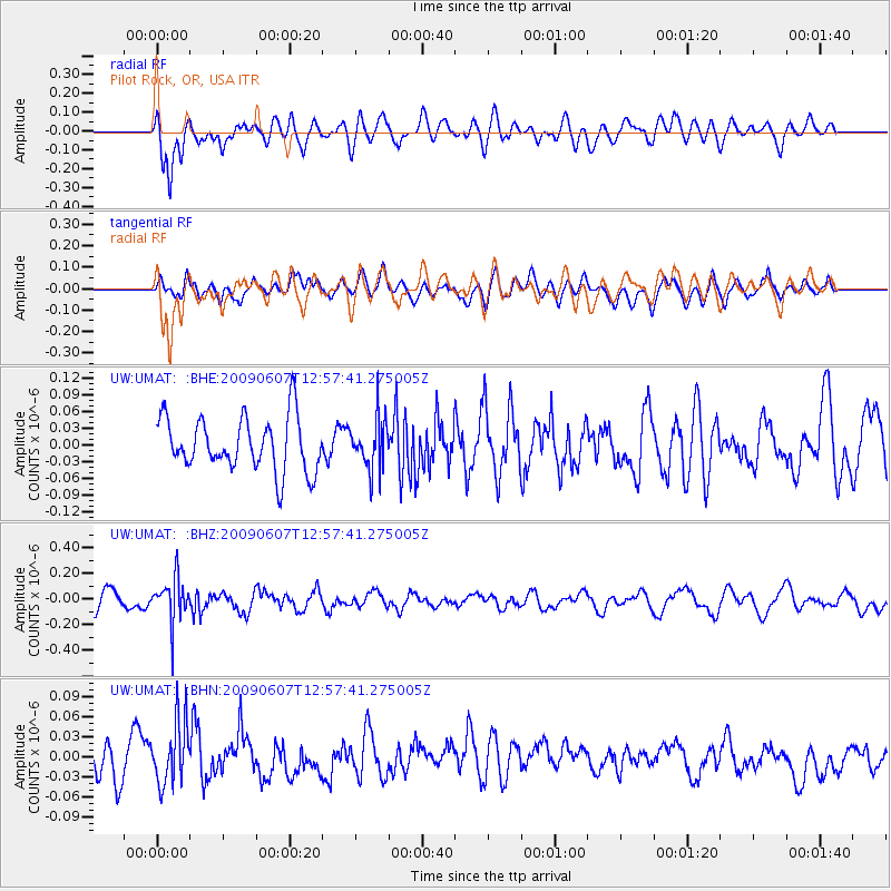
UMAT Pilot Rock, OR, USA - Earthquake Result Viewer
*The percent match for this event was below the threshold and hence no stack was calculated.
| Earthquake location: |
South Of Fiji Islands |
| Earthquake latitude/longitude: |
-22.0/-179.6 |
| Earthquake time(UTC): |
2009/06/07 (158) 12:46:30 GMT |
| Earthquake Depth: |
590 km |
| Earthquake Magnitude: |
5.5 MW, 5.1 MB |
| Earthquake Catalog/Contributor: |
WHDF/NEIC |
|
| Network: |
UW Pacific Northwest Regional Seismic Network |
| Station: |
UMAT Pilot Rock, OR, USA |
| Lat/Lon: |
45.29 N/118.96 W |
| Elevation: |
1318 m |
|
| Distance: |
86.7 deg |
| Az: |
38.034 deg |
| Baz: |
234.079 deg |
| Ray Param: |
$rayparam |
*The percent match for this event was below the threshold and hence was not used in the summary stack. |
|
| Radial Match: |
55.01553 % |
| Radial Bump: |
400 |
| Transverse Match: |
52.187378 % |
| Transverse Bump: |
400 |
| SOD ConfigId: |
2648 |
| Insert Time: |
2010-02-27 05:17:58.630 +0000 |
| GWidth: |
2.5 |
| Max Bumps: |
400 |
| Tol: |
0.001 |
|
Signal To Noise
| Channel | StoN | STA | LTA |
| UW:UMAT: :BHZ:20090607T12:57:41.275005Z | 2.5214782 | 1.6945606E-7 | 6.720504E-8 |
| UW:UMAT: :BHN:20090607T12:57:41.275005Z | 1.9583869 | 4.7197993E-8 | 2.4100443E-8 |
| UW:UMAT: :BHE:20090607T12:57:41.275005Z | 0.9438619 | 4.530588E-8 | 4.800054E-8 |
| Arrivals |
| Ps | |
| PpPs | |
| PsPs/PpSs | |


