You are here: Home > Network List > CB - China National Seismic Network Stations List
> Station XLT Xilinhaote,Neimeng Province > Earthquake Result Viewer
XLT Xilinhaote,Neimeng Province - Earthquake Result Viewer
| Earthquake location: |
Vanuatu Islands |
| Earthquake latitude/longitude: |
-15.1/167.3 |
| Earthquake time(UTC): |
2014/08/27 (239) 23:11:35 GMT |
| Earthquake Depth: |
119 km |
| Earthquake Magnitude: |
5.8 M |
| Earthquake Catalog/Contributor: |
NEIC PDE/NEIC ALERT |
|
| Network: |
CB China National Seismic Network |
| Station: |
XLT Xilinhaote,Neimeng Province |
| Lat/Lon: |
43.90 N/116.08 E |
| Elevation: |
1030 m |
|
| Distance: |
75.0 deg |
| Az: |
324.302 deg |
| Baz: |
128.769 deg |
| Ray Param: |
0.05164669 |
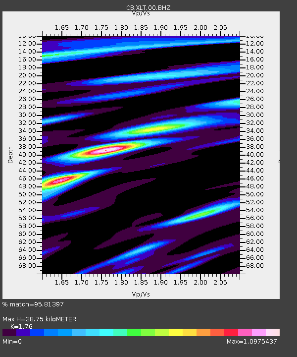
| Estimated Moho Depth: |
38.75 km |
| Estimated Crust Vp/Vs: |
1.76 |
| Assumed Crust Vp: |
6.459 km/s |
| Estimated Crust Vs: |
3.67 km/s |
| Estimated Crust Poisson's Ratio: |
0.26 |
|
| Radial Match: |
95.81397 % |
| Radial Bump: |
304 |
| Transverse Match: |
85.540344 % |
| Transverse Bump: |
339 |
| SOD ConfigId: |
3390531 |
| Insert Time: |
2019-04-13 16:13:48.804 +0000 |
| GWidth: |
2.5 |
| Max Bumps: |
400 |
| Tol: |
0.001 |
|

Signal To Noise
| Channel | StoN | STA | LTA |
| CB:XLT:00:BHZ:20140827T23:22:32.22002Z | 14.859931 | 1.295824E-6 | 8.720256E-8 |
| CB:XLT:00:BHN:20140827T23:22:32.22002Z | 3.9834366 | 2.973067E-7 | 7.463573E-8 |
| CB:XLT:00:BHE:20140827T23:22:32.22002Z | 6.4335675 | 4.9087134E-7 | 7.629847E-8 |
| Arrivals |
| Ps | 4.7 SECOND |
| PpPs | 16 SECOND |
| PsPs/PpSs | 21 SECOND |


