You are here: Home > Network List > IU - Global Seismograph Network (GSN - IRIS/USGS) Stations List
> Station GUMO Guam, Mariana Islands > Earthquake Result Viewer
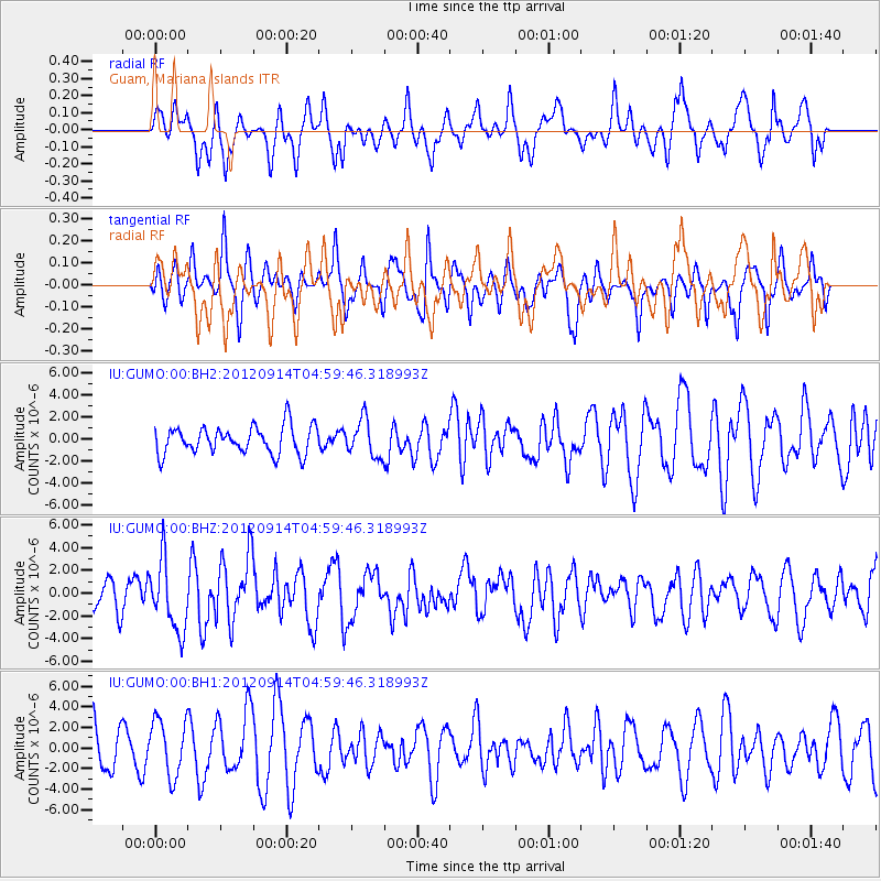
GUMO Guam, Mariana Islands - Earthquake Result Viewer
*The percent match for this event was below the threshold and hence no stack was calculated.
| Earthquake location: |
Southern Sumatra, Indonesia |
| Earthquake latitude/longitude: |
-3.3/100.6 |
| Earthquake time(UTC): |
2012/09/14 (258) 04:51:47 GMT |
| Earthquake Depth: |
19 km |
| Earthquake Magnitude: |
6.1 MB, 6.3 MS, 6.2 MW, 6.2 MW |
| Earthquake Catalog/Contributor: |
WHDF/NEIC |
|
| Network: |
IU Global Seismograph Network (GSN - IRIS/USGS) |
| Station: |
GUMO Guam, Mariana Islands |
| Lat/Lon: |
13.59 N/144.87 E |
| Elevation: |
170 m |
|
| Distance: |
47.0 deg |
| Az: |
68.082 deg |
| Baz: |
252.271 deg |
| Ray Param: |
$rayparam |
*The percent match for this event was below the threshold and hence was not used in the summary stack. |
|
| Radial Match: |
69.16916 % |
| Radial Bump: |
400 |
| Transverse Match: |
57.12956 % |
| Transverse Bump: |
384 |
| SOD ConfigId: |
558545 |
| Insert Time: |
2013-09-17 18:40:21.771 +0000 |
| GWidth: |
2.5 |
| Max Bumps: |
400 |
| Tol: |
0.001 |
|
Signal To Noise
| Channel | StoN | STA | LTA |
| IU:GUMO:00:BHZ:20120914T04:59:46.318993Z | 1.8351524 | 3.0733624E-6 | 1.6747179E-6 |
| IU:GUMO:00:BH1:20120914T04:59:46.318993Z | 1.1604224 | 2.7469014E-6 | 2.3671564E-6 |
| IU:GUMO:00:BH2:20120914T04:59:46.318993Z | 1.3160344 | 1.6474718E-6 | 1.2518454E-6 |
| Arrivals |
| Ps | |
| PpPs | |
| PsPs/PpSs | |


