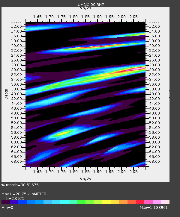
MAJO Matsushiro, Japan - Earthquake Result Viewer
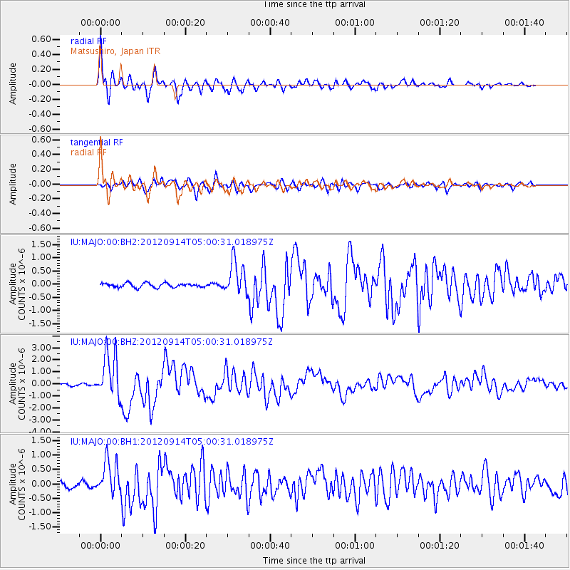
Earthquake location: Southern Sumatra, Indonesia
Earthquake latitude/longitude: -3.3/100.6
Earthquake time(UTC): 2012/09/14 (258) 04:51:47 GMT
Earthquake Depth: 19 km
Earthquake Magnitude: 6.1 MB, 6.3 MS, 6.2 MW, 6.2 MW
Earthquake Catalog/Contributor: WHDF/NEIC
Network: IU Global Seismograph Network (GSN - IRIS/USGS)
Station: MAJO Matsushiro, Japan
Lat/Lon: 36.55 N/138.20 E
Elevation: 405 m
Distance: 52.9 deg
Az: 38.02 deg
Baz: 229.782 deg
Ray Param: 0.06641762
Estimated Moho Depth: 28.75 km
Estimated Crust Vp/Vs: 2.10
Assumed Crust Vp: 6.461 km/s
Estimated Crust Vs: 3.081 km/s
Estimated Crust Poisson's Ratio: 0.35
Radial Match: 90.51675 %
Radial Bump: 400
Transverse Match: 80.408745 %
Transverse Bump: 400
SOD ConfigId: 558545
Insert Time: 2013-09-17 18:40:50.648 +0000
GWidth: 2.5
Max Bumps: 400
Tol: 0.001

Signal To Noise

ChannelStoNSTALTA
IU:MAJO:00:BHZ:20120914T05:00:31.018975Z27.126041.913735E-67.0549746E-8
IU:MAJO:00:BH1:20120914T05:00:31.018975Z6.41625646.1595904E-79.599976E-8
IU:MAJO:00:BH2:20120914T05:00:31.018975Z8.2190666.388929E-77.7733034E-8
Arrivals
Ps5.1 SECOND
PpPs13 SECOND
PsPs/PpSs18 SECOND