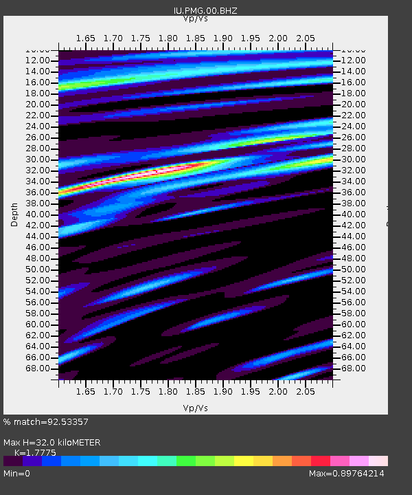
PMG Port Moresby, New Guinea - Earthquake Result Viewer
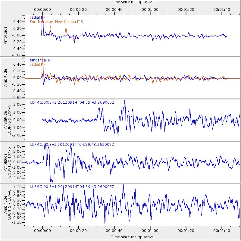
Earthquake location: Southern Sumatra, Indonesia
Earthquake latitude/longitude: -3.3/100.6
Earthquake time(UTC): 2012/09/14 (258) 04:51:47 GMT
Earthquake Depth: 19 km
Earthquake Magnitude: 6.1 MB, 6.3 MS, 6.2 MW, 6.2 MW
Earthquake Catalog/Contributor: WHDF/NEIC
Network: IU Global Seismograph Network (GSN - IRIS/USGS)
Station: PMG Port Moresby, New Guinea
Lat/Lon: 9.40 S/147.16 E
Elevation: 90 m
Distance: 46.6 deg
Az: 99.745 deg
Baz: 274.314 deg
Ray Param: 0.07049819
Estimated Moho Depth: 32.0 km
Estimated Crust Vp/Vs: 1.78
Assumed Crust Vp: 6.122 km/s
Estimated Crust Vs: 3.444 km/s
Estimated Crust Poisson's Ratio: 0.27
Radial Match: 92.53357 %
Radial Bump: 332
Transverse Match: 79.64518 %
Transverse Bump: 400
SOD ConfigId: 558545
Insert Time: 2013-09-17 18:41:04.163 +0000
GWidth: 2.5
Max Bumps: 400
Tol: 0.001

Signal To Noise

ChannelStoNSTALTA
IU:PMG:00:BHZ:20120914T04:59:43.269005Z14.7806362.1534522E-61.4569416E-7
IU:PMG:00:BH1:20120914T04:59:43.269005Z3.15326573.9818462E-71.262769E-7
IU:PMG:00:BH2:20120914T04:59:43.269005Z7.25120839.5107805E-71.3116131E-7
Arrivals
Ps4.3 SECOND
PpPs14 SECOND
PsPs/PpSs18 SECOND