You are here: Home > Network List > II - Global Seismograph Network (GSN - IRIS/IDA) Stations List
> Station WRAB Tennant Creek, NT, Australia > Earthquake Result Viewer
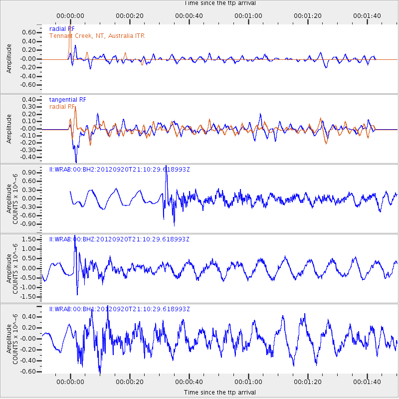
WRAB Tennant Creek, NT, Australia - Earthquake Result Viewer
*The percent match for this event was below the threshold and hence no stack was calculated.
| Earthquake location: |
Fiji Islands Region |
| Earthquake latitude/longitude: |
-20.8/-178.5 |
| Earthquake time(UTC): |
2012/09/20 (264) 21:03:42 GMT |
| Earthquake Depth: |
570 km |
| Earthquake Magnitude: |
5.7 MW, 5.3 MB, 5.7 MW |
| Earthquake Catalog/Contributor: |
WHDF/NEIC |
|
| Network: |
II Global Seismograph Network (GSN - IRIS/IDA) |
| Station: |
WRAB Tennant Creek, NT, Australia |
| Lat/Lon: |
19.93 S/134.36 E |
| Elevation: |
366 m |
|
| Distance: |
44.1 deg |
| Az: |
262.428 deg |
| Baz: |
99.573 deg |
| Ray Param: |
$rayparam |
*The percent match for this event was below the threshold and hence was not used in the summary stack. |
|
| Radial Match: |
63.94547 % |
| Radial Bump: |
400 |
| Transverse Match: |
71.240105 % |
| Transverse Bump: |
400 |
| SOD ConfigId: |
558545 |
| Insert Time: |
2013-09-17 18:53:37.563 +0000 |
| GWidth: |
2.5 |
| Max Bumps: |
400 |
| Tol: |
0.001 |
|
Signal To Noise
| Channel | StoN | STA | LTA |
| II:WRAB:00:BHZ:20120920T21:10:29.618993Z | 2.0336423 | 6.379638E-7 | 3.1370504E-7 |
| II:WRAB:00:BH1:20120920T21:10:29.618993Z | 1.4930542 | 2.254922E-7 | 1.5102746E-7 |
| II:WRAB:00:BH2:20120920T21:10:29.618993Z | 1.819863 | 3.735405E-7 | 2.0525748E-7 |
| Arrivals |
| Ps | |
| PpPs | |
| PsPs/PpSs | |


