You are here: Home > Network List > II - Global Seismograph Network (GSN - IRIS/IDA) Stations List
> Station KAPI Kappang, Sulawesi, Indonesia > Earthquake Result Viewer
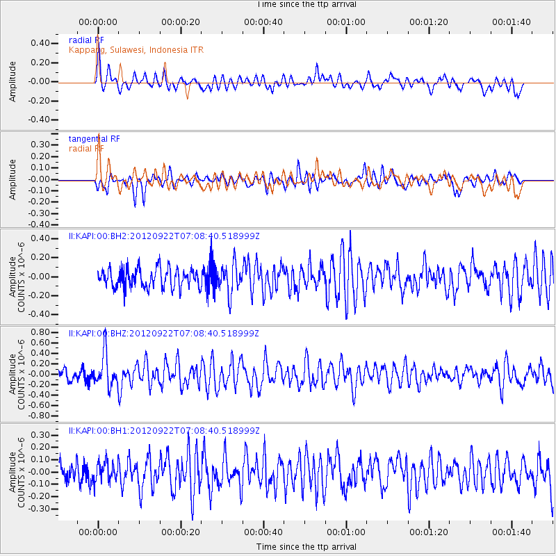
KAPI Kappang, Sulawesi, Indonesia - Earthquake Result Viewer
*The percent match for this event was below the threshold and hence no stack was calculated.
| Earthquake location: |
Tonga Islands |
| Earthquake latitude/longitude: |
-20.9/-174.2 |
| Earthquake time(UTC): |
2012/09/22 (266) 06:58:26 GMT |
| Earthquake Depth: |
11 km |
| Earthquake Magnitude: |
5.5 MW, 5.1 MS, 5.4 MB, 5.6 MW |
| Earthquake Catalog/Contributor: |
WHDF/NEIC |
|
| Network: |
II Global Seismograph Network (GSN - IRIS/IDA) |
| Station: |
KAPI Kappang, Sulawesi, Indonesia |
| Lat/Lon: |
5.01 S/119.75 E |
| Elevation: |
300 m |
|
| Distance: |
65.9 deg |
| Az: |
273.908 deg |
| Baz: |
110.547 deg |
| Ray Param: |
$rayparam |
*The percent match for this event was below the threshold and hence was not used in the summary stack. |
|
| Radial Match: |
74.61935 % |
| Radial Bump: |
400 |
| Transverse Match: |
61.50164 % |
| Transverse Bump: |
400 |
| SOD ConfigId: |
558545 |
| Insert Time: |
2013-09-17 19:00:44.668 +0000 |
| GWidth: |
2.5 |
| Max Bumps: |
400 |
| Tol: |
0.001 |
|
Signal To Noise
| Channel | StoN | STA | LTA |
| II:KAPI:00:BHZ:20120922T07:08:40.518999Z | 2.3143096 | 3.2166244E-7 | 1.3898851E-7 |
| II:KAPI:00:BH1:20120922T07:08:40.518999Z | 0.9723798 | 7.926056E-8 | 8.1511935E-8 |
| II:KAPI:00:BH2:20120922T07:08:40.518999Z | 1.5955217 | 1.5691836E-7 | 9.834925E-8 |
| Arrivals |
| Ps | |
| PpPs | |
| PsPs/PpSs | |


