You are here: Home > Network List > IU - Global Seismograph Network (GSN - IRIS/USGS) Stations List
> Station SAML Samuel, Brazil > Earthquake Result Viewer
SAML Samuel, Brazil - Earthquake Result Viewer
| Earthquake location: |
Baja California, Mexico |
| Earthquake latitude/longitude: |
24.7/-110.2 |
| Earthquake time(UTC): |
2012/09/25 (269) 23:45:24 GMT |
| Earthquake Depth: |
10 km |
| Earthquake Magnitude: |
5.9 MB, 6.1 MS, 6.3 MW, 6.3 MW |
| Earthquake Catalog/Contributor: |
WHDF/NEIC |
|
| Network: |
IU Global Seismograph Network (GSN - IRIS/USGS) |
| Station: |
SAML Samuel, Brazil |
| Lat/Lon: |
8.95 S/63.18 W |
| Elevation: |
120 m |
|
| Distance: |
56.7 deg |
| Az: |
120.189 deg |
| Baz: |
307.252 deg |
| Ray Param: |
0.06397034 |
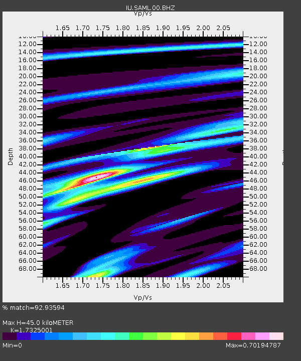
| Estimated Moho Depth: |
45.0 km |
| Estimated Crust Vp/Vs: |
1.73 |
| Assumed Crust Vp: |
6.498 km/s |
| Estimated Crust Vs: |
3.75 km/s |
| Estimated Crust Poisson's Ratio: |
0.25 |
|
| Radial Match: |
92.93594 % |
| Radial Bump: |
357 |
| Transverse Match: |
75.08199 % |
| Transverse Bump: |
400 |
| SOD ConfigId: |
558545 |
| Insert Time: |
2013-09-17 19:18:09.745 +0000 |
| GWidth: |
2.5 |
| Max Bumps: |
400 |
| Tol: |
0.001 |
|

Signal To Noise
| Channel | StoN | STA | LTA |
| IU:SAML:00:BHZ:20120925T23:54:37.518979Z | 10.462426 | 2.6855253E-6 | 2.5668282E-7 |
| IU:SAML:00:BH1:20120925T23:54:37.518979Z | 5.2245913 | 1.1808525E-6 | 2.2601817E-7 |
| IU:SAML:00:BH2:20120925T23:54:37.518979Z | 6.954461 | 8.4813433E-7 | 1.2195544E-7 |
| Arrivals |
| Ps | 5.3 SECOND |
| PpPs | 18 SECOND |
| PsPs/PpSs | 23 SECOND |


