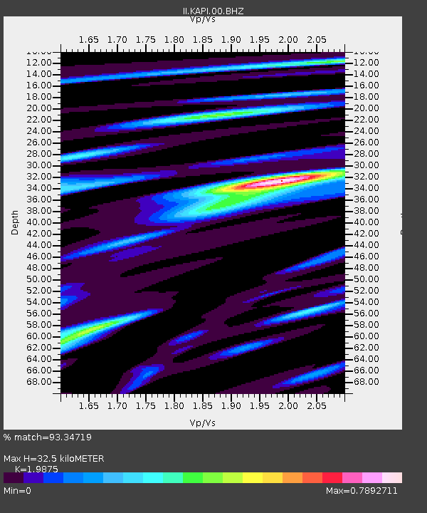
KAPI Kappang, Sulawesi, Indonesia - Earthquake Result Viewer

Earthquake location: Andreanof Islands, Aleutian Is.
Earthquake latitude/longitude: 51.6/-178.3
Earthquake time(UTC): 2012/09/26 (270) 23:39:55 GMT
Earthquake Depth: 16 km
Earthquake Magnitude: 6.3 MB, 6.5 MS, 6.4 MW, 6.4 MW
Earthquake Catalog/Contributor: WHDF/NEIC
Network: II Global Seismograph Network (GSN - IRIS/IDA)
Station: KAPI Kappang, Sulawesi, Indonesia
Lat/Lon: 5.01 S/119.75 E
Elevation: 300 m
Distance: 77.0 deg
Az: 244.453 deg
Baz: 34.4 deg
Ray Param: 0.050582282
Estimated Moho Depth: 32.5 km
Estimated Crust Vp/Vs: 1.99
Assumed Crust Vp: 6.343 km/s
Estimated Crust Vs: 3.192 km/s
Estimated Crust Poisson's Ratio: 0.33
Radial Match: 93.34719 %
Radial Bump: 397
Transverse Match: 79.5581 %
Transverse Bump: 400
SOD ConfigId: 558545
Insert Time: 2013-09-17 19:20:20.241 +0000
GWidth: 2.5
Max Bumps: 400
Tol: 0.001

Signal To Noise

ChannelStoNSTALTA
II:KAPI:00:BHZ:20120926T23:51:15.868972Z17.1437592.276657E-61.32798E-7
II:KAPI:00:BH1:20120926T23:51:15.868972Z6.42558538.304427E-71.2924001E-7
II:KAPI:00:BH2:20120926T23:51:15.868972Z3.3408196.638446E-71.9870714E-7
Arrivals
Ps5.2 SECOND
PpPs15 SECOND
PsPs/PpSs20 SECOND