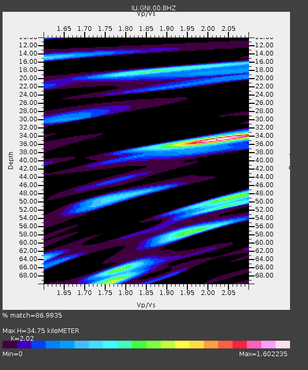
GNI Garni, Armenia - Earthquake Result Viewer
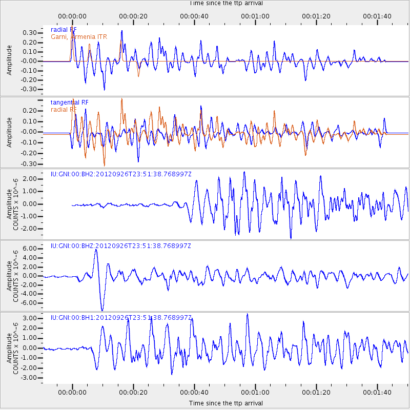
Earthquake location: Andreanof Islands, Aleutian Is.
Earthquake latitude/longitude: 51.6/-178.3
Earthquake time(UTC): 2012/09/26 (270) 23:39:55 GMT
Earthquake Depth: 16 km
Earthquake Magnitude: 6.3 MB, 6.5 MS, 6.4 MW, 6.4 MW
Earthquake Catalog/Contributor: WHDF/NEIC
Network: IU Global Seismograph Network (GSN - IRIS/USGS)
Station: GNI Garni, Armenia
Lat/Lon: 40.15 N/44.74 E
Elevation: 1609 m
Distance: 81.2 deg
Az: 328.042 deg
Baz: 25.516 deg
Ray Param: 0.04772097
Estimated Moho Depth: 34.75 km
Estimated Crust Vp/Vs: 2.02
Assumed Crust Vp: 6.291 km/s
Estimated Crust Vs: 3.114 km/s
Estimated Crust Poisson's Ratio: 0.34
Radial Match: 86.9935 %
Radial Bump: 400
Transverse Match: 77.47336 %
Transverse Bump: 400
SOD ConfigId: 558545
Insert Time: 2013-09-17 19:21:28.207 +0000
GWidth: 2.5
Max Bumps: 400
Tol: 0.001

Signal To Noise

ChannelStoNSTALTA
IU:GNI:00:BHZ:20120926T23:51:38.768997Z6.3682015.429543E-78.526023E-8
IU:GNI:00:BH1:20120926T23:51:38.768997Z1.32459631.0280772E-77.761438E-8
IU:GNI:00:BH2:20120926T23:51:38.768997Z1.70124361.2221604E-77.183923E-8
Arrivals
Ps5.8 SECOND
PpPs16 SECOND
PsPs/PpSs22 SECOND