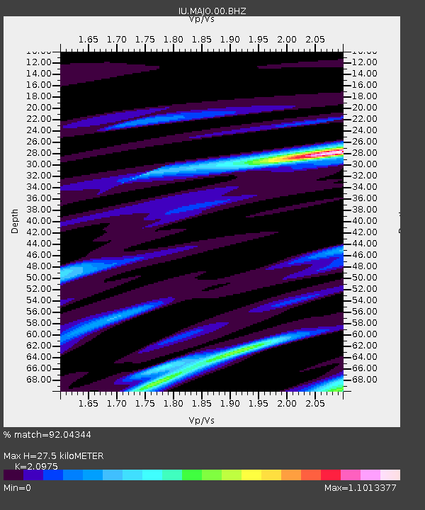
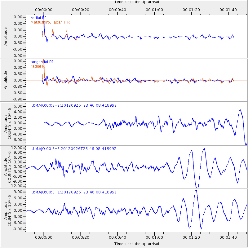
MAJO Matsushiro, Japan - Earthquake Result Viewer

Earthquake location: Andreanof Islands, Aleutian Is.
Earthquake latitude/longitude: 51.6/-178.3
Earthquake time(UTC): 2012/09/26 (270) 23:39:55 GMT
Earthquake Depth: 16 km
Earthquake Magnitude: 6.3 MB, 6.5 MS, 6.4 MW, 6.4 MW
Earthquake Catalog/Contributor: WHDF/NEIC
Network: IU Global Seismograph Network (GSN - IRIS/USGS)
Station: MAJO Matsushiro, Japan
Lat/Lon: 36.55 N/138.20 E
Elevation: 405 m
Distance: 34.1 deg
Az: 261.112 deg
Baz: 49.938 deg
Ray Param: 0.07787631
Estimated Moho Depth: 27.5 km
Estimated Crust Vp/Vs: 2.10
Assumed Crust Vp: 6.461 km/s
Estimated Crust Vs: 3.081 km/s
Estimated Crust Poisson's Ratio: 0.35
Radial Match: 92.04344 %
Radial Bump: 334
Transverse Match: 69.16461 %
Transverse Bump: 400
SOD ConfigId: 558545
Insert Time: 2013-09-17 19:22:05.122 +0000
GWidth: 2.5
Max Bumps: 400
Tol: 0.001

Signal To Noise

ChannelStoNSTALTA
IU:MAJO:00:BHZ:20120926T23:46:08.41899Z2.94940161.6440574E-65.5742066E-7
IU:MAJO:00:BH1:20120926T23:46:08.41899Z2.32988487.770259E-73.3350398E-7
IU:MAJO:00:BH2:20120926T23:46:08.41899Z1.86928058.449183E-74.520019E-7
Arrivals
Ps5.0 SECOND
PpPs12 SECOND
PsPs/PpSs17 SECOND