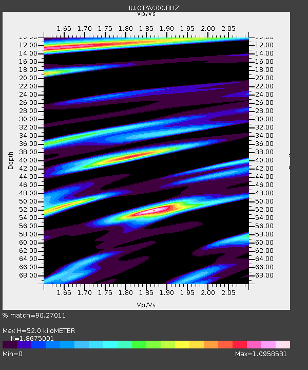
OTAV Otavalo, Ecuador - Earthquake Result Viewer
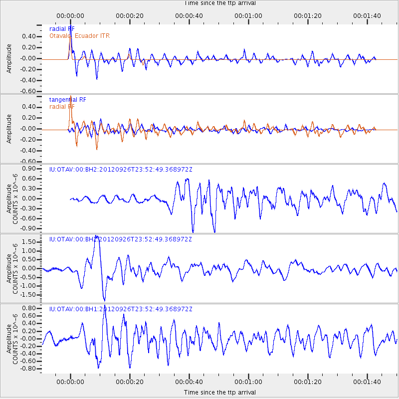
Earthquake location: Andreanof Islands, Aleutian Is.
Earthquake latitude/longitude: 51.6/-178.3
Earthquake time(UTC): 2012/09/26 (270) 23:39:55 GMT
Earthquake Depth: 16 km
Earthquake Magnitude: 6.3 MB, 6.5 MS, 6.4 MW, 6.4 MW
Earthquake Catalog/Contributor: WHDF/NEIC
Network: IU Global Seismograph Network (GSN - IRIS/USGS)
Station: OTAV Otavalo, Ecuador
Lat/Lon: 0.24 N/78.45 W
Elevation: 3510 m
Distance: 95.9 deg
Az: 82.13 deg
Baz: 321.834 deg
Ray Param: 0.04064635
Estimated Moho Depth: 52.0 km
Estimated Crust Vp/Vs: 1.87
Assumed Crust Vp: 6.472 km/s
Estimated Crust Vs: 3.466 km/s
Estimated Crust Poisson's Ratio: 0.30
Radial Match: 90.27011 %
Radial Bump: 400
Transverse Match: 79.7956 %
Transverse Bump: 400
SOD ConfigId: 558545
Insert Time: 2013-09-17 19:22:26.598 +0000
GWidth: 2.5
Max Bumps: 400
Tol: 0.001

Signal To Noise

ChannelStoNSTALTA
IU:OTAV:00:BHZ:20120926T23:52:49.368972Z7.209254.9248547E-76.831299E-8
IU:OTAV:00:BH1:20120926T23:52:49.368972Z1.34467041.7638989E-71.3117703E-7
IU:OTAV:00:BH2:20120926T23:52:49.368972Z2.54761081.8854807E-77.400976E-8
Arrivals
Ps7.1 SECOND
PpPs23 SECOND
PsPs/PpSs30 SECOND