PMG Port Moresby, New Guinea - Earthquake Result Viewer
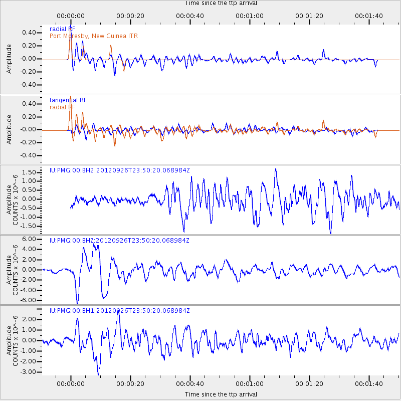
Earthquake location: Andreanof Islands, Aleutian Is.
Earthquake latitude/longitude: 51.6/-178.3
Earthquake time(UTC): 2012/09/26 (270) 23:39:55 GMT
Earthquake Depth: 16 km
Earthquake Magnitude: 6.3 MB, 6.5 MS, 6.4 MW, 6.4 MW
Earthquake Catalog/Contributor: WHDF/NEIC
Network: IU Global Seismograph Network (GSN - IRIS/USGS)
Station: PMG Port Moresby, New Guinea
Lat/Lon: 9.40 S/147.16 E
Elevation: 90 m
Distance: 67.7 deg
Az: 217.225 deg
Baz: 22.486 deg
Ray Param: 0.056800436
Estimated Moho Depth: 40.5 km
Estimated Crust Vp/Vs: 1.60
Assumed Crust Vp: 6.122 km/s
Estimated Crust Vs: 3.826 km/s
Estimated Crust Poisson's Ratio: 0.18
Radial Match: 91.9262 %
Radial Bump: 400
Transverse Match: 82.30028 %
Transverse Bump: 400
SOD ConfigId: 558545
Insert Time: 2013-09-17 19:22:40.944 +0000
GWidth: 2.5
Max Bumps: 400
Tol: 0.001

Signal To Noise

ChannelStoNSTALTA
IU:PMG:00:BHZ:20120926T23:50:20.068984Z18.9805873.011956E-61.5868613E-7
IU:PMG:00:BH1:20120926T23:50:20.068984Z6.07692538.904318E-71.465267E-7
IU:PMG:00:BH2:20120926T23:50:20.068984Z3.36042214.7440585E-71.4117448E-7
Arrivals
Ps4.1 SECOND
PpPs17 SECOND
PsPs/PpSs21 SECOND