You are here: Home > Network List > US - United States National Seismic Network Stations List
> Station AMTX Amarillo, Texas, USA > Earthquake Result Viewer
AMTX Amarillo, Texas, USA - Earthquake Result Viewer
*The percent match for this event was below the threshold and hence no stack was calculated.
| Earthquake location: |
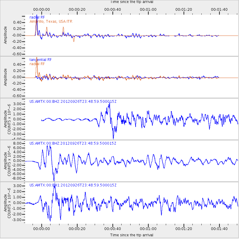
Andreanof Islands, Aleutian Is. |
| Earthquake latitude/longitude: |
51.6/-178.3 |
| Earthquake time(UTC): |
2012/09/26 (270) 23:39:55 GMT |
| Earthquake Depth: |
16 km |
| Earthquake Magnitude: |
6.3 MB, 6.5 MS, 6.4 MW, 6.4 MW |
| Earthquake Catalog/Contributor: |
WHDF/NEIC |
|
| Network: |
US United States National Seismic Network |
| Station: |
AMTX Amarillo, Texas, USA |
| Lat/Lon: |
34.53 N/101.41 W |
| Elevation: |
1010 m |
|
| Distance: |
56.1 deg |
| Az: |
75.657 deg |
| Baz: |
312.942 deg |
| Ray Param: |
$rayparam |
*The percent match for this event was below the threshold and hence was not used in the summary stack. |
|
| Radial Match: |
96.48839 % |
| Radial Bump: |
396 |
| Transverse Match: |
78.8202 % |
| Transverse Bump: |
400 |
| SOD ConfigId: |
558545 |
| Insert Time: |
2013-09-17 19:24:14.500 +0000 |
| GWidth: |
2.5 |
| Max Bumps: |
400 |
| Tol: |
0.001 |
|
Signal To Noise
| Channel | StoN | STA | LTA |
| US:AMTX:00:BHZ:20120926T23:48:59.500015Z | 34.450287 | 4.0165337E-6 | 1.1658926E-7 |
| US:AMTX:00:BH1:20120926T23:48:59.500015Z | 11.106497 | 1.3456465E-6 | 1.2115851E-7 |
| US:AMTX:00:BH2:20120926T23:48:59.500015Z | 8.8745 | 1.2502966E-6 | 1.4088641E-7 |
| Arrivals |
| Ps | |
| PpPs | |
| PsPs/PpSs | |


