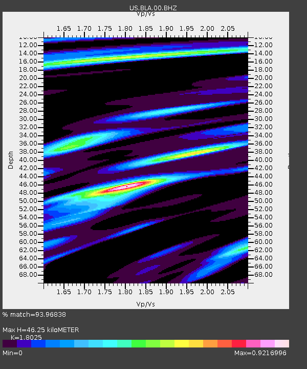
BLA Blacksburg, Virginia, USA - Earthquake Result Viewer
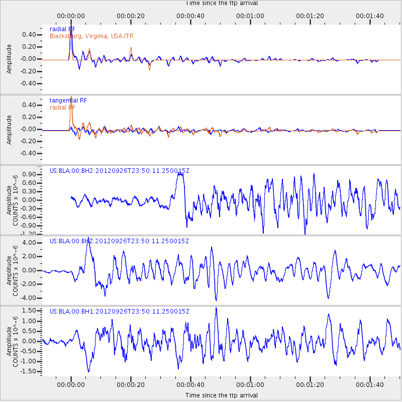
Earthquake location: Andreanof Islands, Aleutian Is.
Earthquake latitude/longitude: 51.6/-178.3
Earthquake time(UTC): 2012/09/26 (270) 23:39:55 GMT
Earthquake Depth: 16 km
Earthquake Magnitude: 6.3 MB, 6.5 MS, 6.4 MW, 6.4 MW
Earthquake Catalog/Contributor: WHDF/NEIC
Network: US United States National Seismic Network
Station: BLA Blacksburg, Virginia, USA
Lat/Lon: 37.21 N/80.42 W
Elevation: 634 m
Distance: 66.3 deg
Az: 59.754 deg
Baz: 317.546 deg
Ray Param: 0.057713274
Estimated Moho Depth: 46.25 km
Estimated Crust Vp/Vs: 1.80
Assumed Crust Vp: 6.159 km/s
Estimated Crust Vs: 3.417 km/s
Estimated Crust Poisson's Ratio: 0.28
Radial Match: 93.96838 %
Radial Bump: 274
Transverse Match: 83.438805 %
Transverse Bump: 400
SOD ConfigId: 558545
Insert Time: 2013-09-17 19:24:21.174 +0000
GWidth: 2.5
Max Bumps: 400
Tol: 0.001

Signal To Noise

ChannelStoNSTALTA
US:BLA:00:BHZ:20120926T23:50:11.250015Z5.2332696.977014E-71.3332037E-7
US:BLA:00:BH1:20120926T23:50:11.250015Z3.53927372.9378504E-78.300715E-8
US:BLA:00:BH2:20120926T23:50:11.250015Z1.83801141.8186167E-79.8944795E-8
Arrivals
Ps6.3 SECOND
PpPs20 SECOND
PsPs/PpSs27 SECOND