You are here: Home > Network List > US - United States National Seismic Network Stations List
> Station DGMT Dagmar, Montana, USA > Earthquake Result Viewer
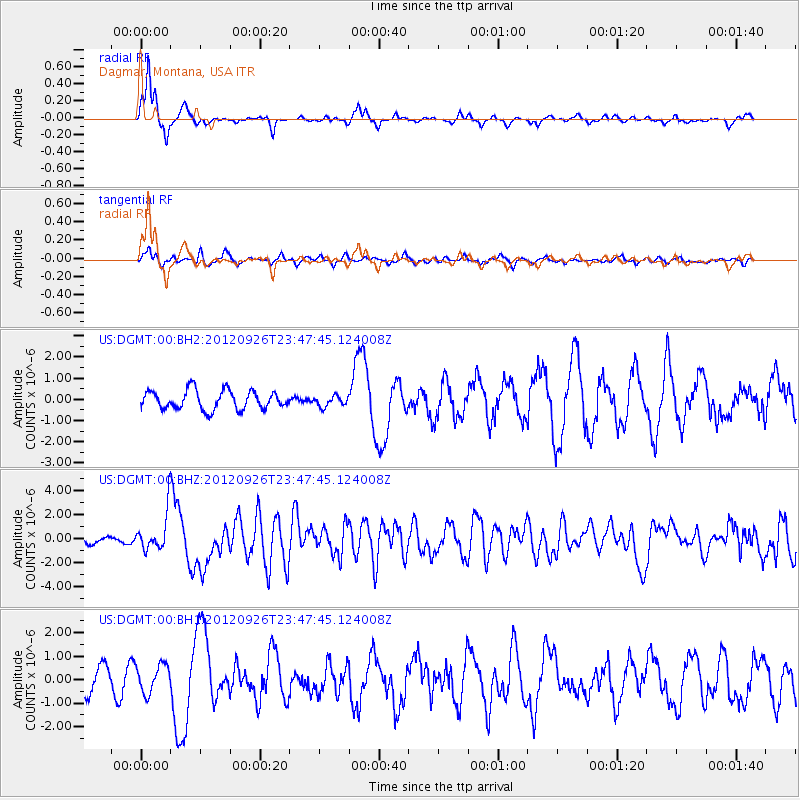
DGMT Dagmar, Montana, USA - Earthquake Result Viewer
*The percent match for this event was below the threshold and hence no stack was calculated.
| Earthquake location: |
Andreanof Islands, Aleutian Is. |
| Earthquake latitude/longitude: |
51.6/-178.3 |
| Earthquake time(UTC): |
2012/09/26 (270) 23:39:55 GMT |
| Earthquake Depth: |
16 km |
| Earthquake Magnitude: |
6.3 MB, 6.5 MS, 6.4 MW, 6.4 MW |
| Earthquake Catalog/Contributor: |
WHDF/NEIC |
|
| Network: |
US United States National Seismic Network |
| Station: |
DGMT Dagmar, Montana, USA |
| Lat/Lon: |
48.47 N/104.20 W |
| Elevation: |
0.0 m |
|
| Distance: |
45.8 deg |
| Az: |
63.214 deg |
| Baz: |
303.199 deg |
| Ray Param: |
$rayparam |
*The percent match for this event was below the threshold and hence was not used in the summary stack. |
|
| Radial Match: |
79.53535 % |
| Radial Bump: |
286 |
| Transverse Match: |
52.965828 % |
| Transverse Bump: |
392 |
| SOD ConfigId: |
558545 |
| Insert Time: |
2013-09-17 19:24:53.742 +0000 |
| GWidth: |
2.5 |
| Max Bumps: |
400 |
| Tol: |
0.001 |
|
Signal To Noise
| Channel | StoN | STA | LTA |
| US:DGMT:00:BHZ:20120926T23:47:45.124008Z | 5.1592064 | 1.5729297E-6 | 3.0487823E-7 |
| US:DGMT:00:BH1:20120926T23:47:45.124008Z | 1.4483851 | 5.938258E-7 | 4.0999166E-7 |
| US:DGMT:00:BH2:20120926T23:47:45.124008Z | 0.56652707 | 2.4987784E-7 | 4.4106957E-7 |
| Arrivals |
| Ps | |
| PpPs | |
| PsPs/PpSs | |


