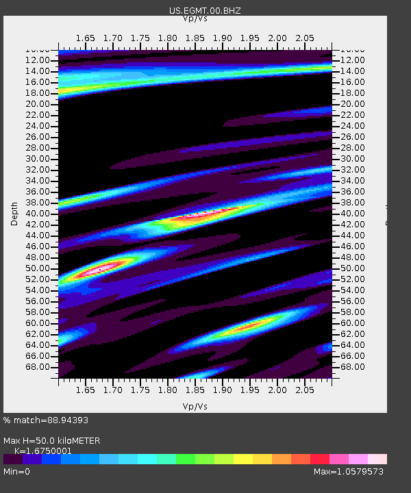
EGMT Eagleton, Montana, USA - Earthquake Result Viewer
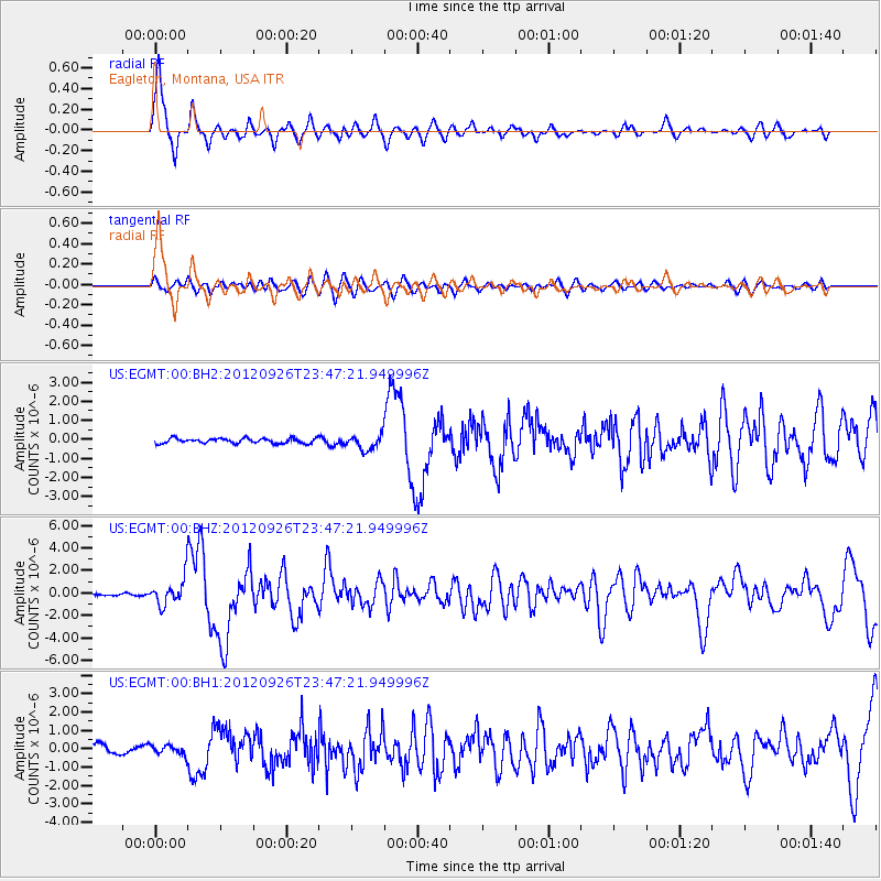
Earthquake location: Andreanof Islands, Aleutian Is.
Earthquake latitude/longitude: 51.6/-178.3
Earthquake time(UTC): 2012/09/26 (270) 23:39:55 GMT
Earthquake Depth: 16 km
Earthquake Magnitude: 6.3 MB, 6.5 MS, 6.4 MW, 6.4 MW
Earthquake Catalog/Contributor: WHDF/NEIC
Network: US United States National Seismic Network
Station: EGMT Eagleton, Montana, USA
Lat/Lon: 48.02 N/109.75 W
Elevation: 1055 m
Distance: 42.9 deg
Az: 66.595 deg
Baz: 301.481 deg
Ray Param: 0.07287668
Estimated Moho Depth: 50.0 km
Estimated Crust Vp/Vs: 1.68
Assumed Crust Vp: 6.438 km/s
Estimated Crust Vs: 3.843 km/s
Estimated Crust Poisson's Ratio: 0.22
Radial Match: 88.94393 %
Radial Bump: 344
Transverse Match: 72.59395 %
Transverse Bump: 400
SOD ConfigId: 558545
Insert Time: 2013-09-17 19:25:06.537 +0000
GWidth: 2.5
Max Bumps: 400
Tol: 0.001

Signal To Noise

ChannelStoNSTALTA
US:EGMT:00:BHZ:20120926T23:47:21.949996Z12.1819071.2502124E-61.0262863E-7
US:EGMT:00:BH1:20120926T23:47:21.949996Z1.1074272.5799912E-72.3297169E-7
US:EGMT:00:BH2:20120926T23:47:21.949996Z3.1246274.061523E-71.2998426E-7
Arrivals
Ps5.6 SECOND
PpPs19 SECOND
PsPs/PpSs25 SECOND