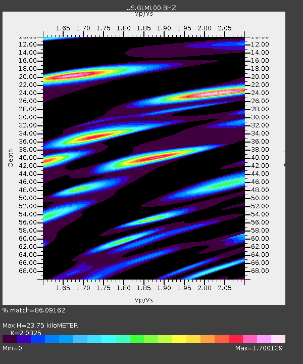
GLMI Grayling, Michigan, USA - Earthquake Result Viewer

Earthquake location: Andreanof Islands, Aleutian Is.
Earthquake latitude/longitude: 51.6/-178.3
Earthquake time(UTC): 2012/09/26 (270) 23:39:55 GMT
Earthquake Depth: 16 km
Earthquake Magnitude: 6.3 MB, 6.5 MS, 6.4 MW, 6.4 MW
Earthquake Catalog/Contributor: WHDF/NEIC
Network: US United States National Seismic Network
Station: GLMI Grayling, Michigan, USA
Lat/Lon: 44.82 N/84.62 W
Elevation: 387 m
Distance: 58.6 deg
Az: 56.282 deg
Baz: 313.186 deg
Ray Param: 0.06270792
Estimated Moho Depth: 23.75 km
Estimated Crust Vp/Vs: 2.03
Assumed Crust Vp: 6.483 km/s
Estimated Crust Vs: 3.189 km/s
Estimated Crust Poisson's Ratio: 0.34
Radial Match: 86.09162 %
Radial Bump: 400
Transverse Match: 59.672295 %
Transverse Bump: 400
SOD ConfigId: 558545
Insert Time: 2013-09-17 19:25:29.156 +0000
GWidth: 2.5
Max Bumps: 400
Tol: 0.001

Signal To Noise

ChannelStoNSTALTA
US:GLMI:00:BHZ:20120926T23:49:20.250015Z3.66604458.582844E-72.341173E-7
US:GLMI:00:BH1:20120926T23:49:20.250015Z1.27268044.309526E-73.3861812E-7
US:GLMI:00:BH2:20120926T23:49:20.250015Z1.15139733.916226E-73.4012808E-7
Arrivals
Ps3.9 SECOND
PpPs11 SECOND
PsPs/PpSs15 SECOND