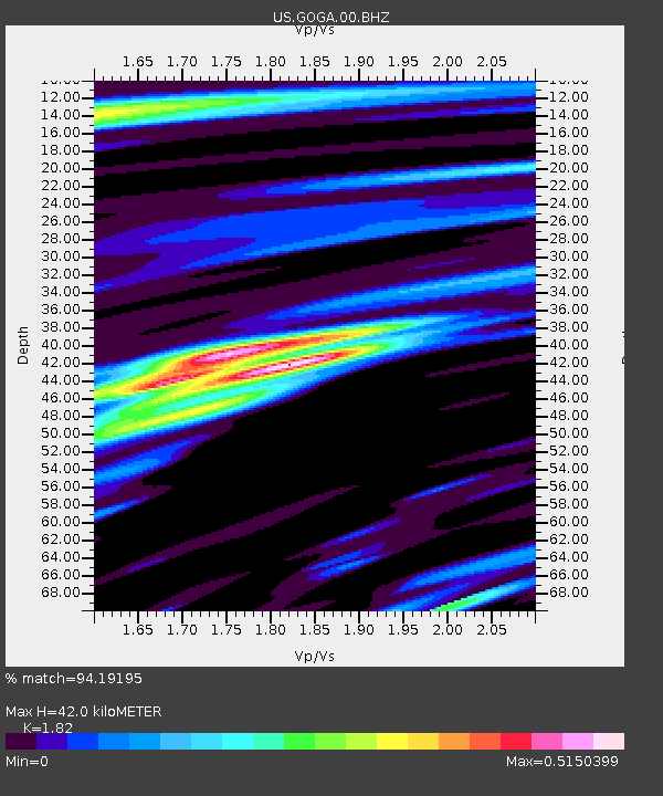
GOGA Godfrey, Georgia, USA - Earthquake Result Viewer
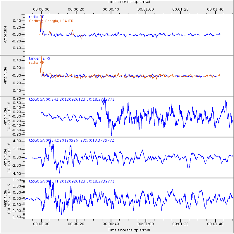
Earthquake location: Andreanof Islands, Aleutian Is.
Earthquake latitude/longitude: 51.6/-178.3
Earthquake time(UTC): 2012/09/26 (270) 23:39:55 GMT
Earthquake Depth: 16 km
Earthquake Magnitude: 6.3 MB, 6.5 MS, 6.4 MW, 6.4 MW
Earthquake Catalog/Contributor: WHDF/NEIC
Network: US United States National Seismic Network
Station: GOGA Godfrey, Georgia, USA
Lat/Lon: 33.41 N/83.47 W
Elevation: 150 m
Distance: 67.4 deg
Az: 64.535 deg
Baz: 317.674 deg
Ray Param: 0.056974422
Estimated Moho Depth: 42.0 km
Estimated Crust Vp/Vs: 1.82
Assumed Crust Vp: 6.565 km/s
Estimated Crust Vs: 3.607 km/s
Estimated Crust Poisson's Ratio: 0.28
Radial Match: 94.19195 %
Radial Bump: 400
Transverse Match: 68.99205 %
Transverse Bump: 400
SOD ConfigId: 558545
Insert Time: 2013-09-17 19:25:30.952 +0000
GWidth: 2.5
Max Bumps: 400
Tol: 0.001

Signal To Noise

ChannelStoNSTALTA
US:GOGA:00:BHZ:20120926T23:50:18.373977Z17.9755041.358629E-67.558226E-8
US:GOGA:00:BH1:20120926T23:50:18.373977Z9.3273075.324696E-75.7087178E-8
US:GOGA:00:BH2:20120926T23:50:18.373977Z2.19554022.0571613E-79.3697274E-8
Arrivals
Ps5.5 SECOND
PpPs17 SECOND
PsPs/PpSs23 SECOND